
Dufourkarte
Die Topographische Karte der Schweiz 1:100 000 (Dufourkarte) ist das erste amtliche Kartenwerk, das die Schweiz landesweit abdeckt. Sie wurde zwischen 1845 und 1865 publiziert und entstand damit parallel zum modernen Bundesstaat.
Vorgeschichte
Nach ersten Ansätzen in der Helvetik (1798–1803) wurden ab 1809 erste Vermessungen auf eidgenössischer Ebene durch die Offiziere des Quartiermeisterstabs vorgenommen. Doch die Arbeiten kamen erst richtig vom Fleck, als Guillaume Henri Dufour (1787–1875) 1832 zum Oberstquartiermeister der Eidgenossenschaft (Generalstabschef) ernannt wurde. Zu seinen Aufgaben gehörte auch die Erstellung der Topographischen Karte der Schweiz 1:100 000.
Geodätische Grundlagen
Dufour arbeitete mit zahlreichen Wissenschaftlern, Topografen und Kupferstechern zusammen. Zunächst verband der Astronom und Geodät Johannes Eschmann (1808– 1852) zwischen 1834 und 1837 verschiedene bereits vorliegende kantonale Netze zur «Triangulation primordiale», dem ersten landesweiten Dreiecksnetz, welches die Teile nördlich der Alpen mit den südlichen verband. Eschmann publizierte 1840 die «Ergebnisse der trigonometrischen Vermessungen in der Schweiz», die der Dufourkarte als geodätisches Bezugssystem dienten.
Topografische Grundlagen
Parallel dazu wurden die topografischen Aufnahmen in Angriff genommen. Dufour musste sich ein Netz von Mitarbeitern aufbauen, die in seinem Auftrag topografische Grundlagen lieferten. Um die eingehenden Arbeiten mit einem kleinen Mitarbeiterstab zu prüfen, in den Massstab der zukünftigen Karte umzuarbeiten und anschliessend in Kupfer zu stechen, gründete Dufour 1838 in Genf das Eidgenössische Topographische Bureau.
Im Mittelland, Jura und Südtessin wurden die Grundlagen zur Dufourkarte mit dem Messtisch im Massstab 1:25 000 kartiert, im Alpengebiet in 1:50 000. Ausgehend von wenigen Triangulationspunkten, deren Koordinaten und Höhe bereits vor Beginn der Aufnahmen mit Dreiecksmessungen ermittelt worden waren, mussten die Topografen zuerst das Gefüge der Fixpunkte mit einer grafischen Triangulation direkt im Aufnahmemassstab verdichten. Anschliessend konnten sie nach genauen Instruktionen das Gelände aufnehmen, wobei sie davon ausgingen, dass ihre Grundlagen „nur“ in vierfacher oder zweifacher Verkleinerung publiziert wurden. Das Resultat dieses Arbeitsschrittes wird bei swisstopo als „Originalaufnahme“ bezeichnet.
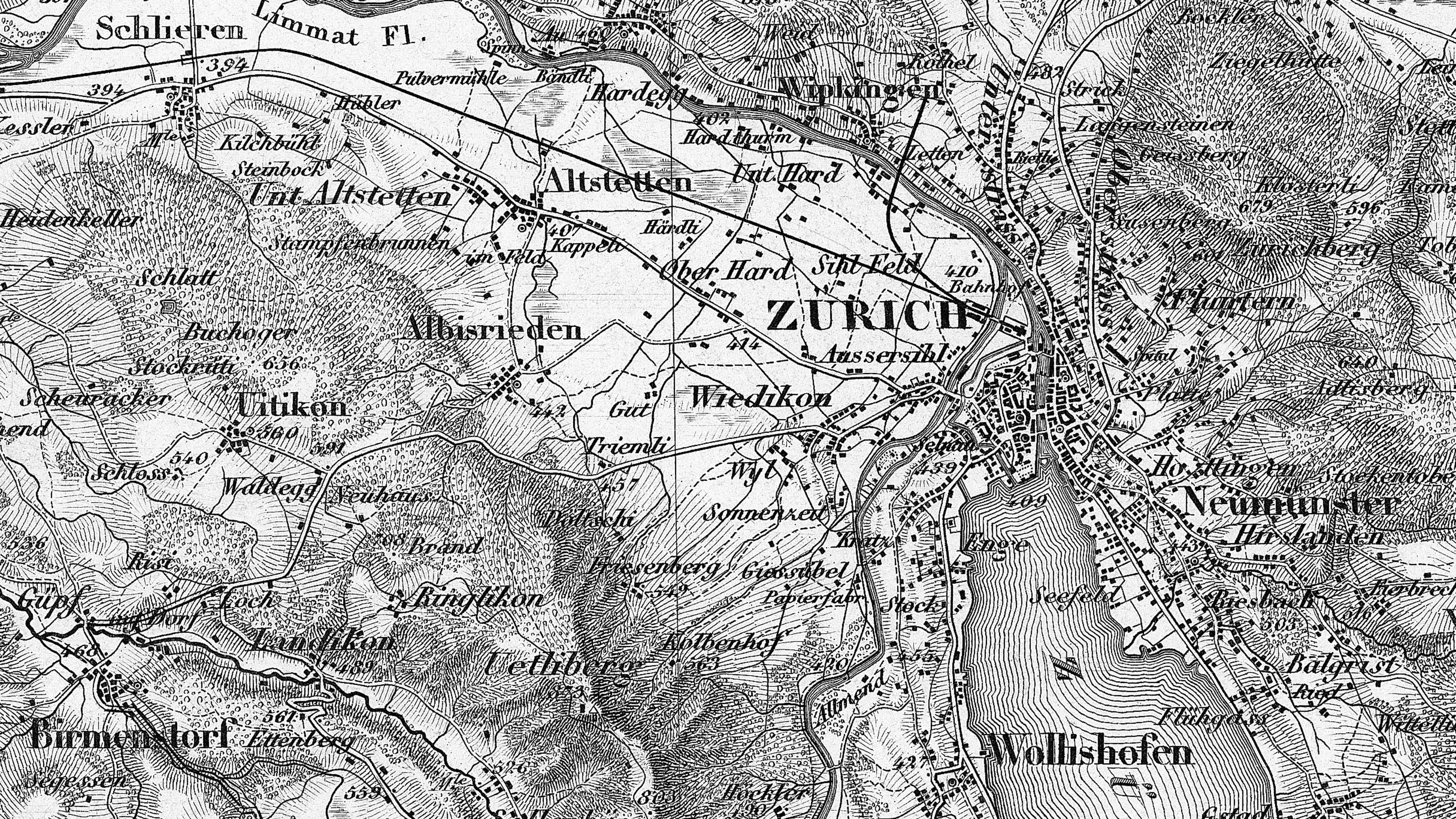
Einzelne Kantone publizierten, teilweise durch Private, teilweise auf Staatskosten kantonale Kartenwerke, deren Grundlagen sie dem Eidgenössischen Topographischen Bureau für die Umarbeitung in die eidgenössische Karte zur Verfügung stellten, wie Basel-Stadt (1836), Neuenburg (1838–1845), Thurgau (1839), Genf (1842), Aargau (1845–1848), Zug (1850), St. Gallen und Appenzell (1851–1856), Freiburg (1855) Zürich (1852–1865), Neuenburg (1858), Waadt (1862–1885), Luzern (1864–1867). Dies ist auch der Grund, warum die topografischen Grundlagen der Dufourkarte nur zum Teil in der Kartensammlung von swisstopo verfügbar und über grosse Gebiete in den kantonalen Archiven zu suchen sind. Zudem ist zu beachten, dass in gewissen Kantonen die Dufourkarte auf den gleichen Grundlagen beruht wie der Topographische Atlas der Schweiz 1:25 000 / 1:50 000 (Siegfriedkarte).
Blatteinteilung
Schon zu Beginn der Arbeiten legte Dufour den äusseren Rahmen für das Kartenwerk fest, das aus einem Raster (Blatteinteilung) von fünf mal fünf Blättern bestehen sollte. Jedes Blatt umfasst 70 km in West-Ost- und 48 km in Nord-Süd-Richtung. Das gesamte Kartenwerk deckt somit eine Fläche von 350 x 240 km ab, wobei die Eckblätter für den Titel und weitere Zusätze reserviert blieben und höchstens teilweise topografische Informationen enthalten. Für die Originalaufnahmen im Massstab 1:50 000 wurde ein Blatt in 16 Sektionen (jede 17.5 x 12 km) unterteilt. Für den Massstab 1:25 000 wurde jede Sektion nochmals in vier Teile (8.75 x 6 km) zerlegt.
Reproduktion
Die Originalaufnahmen wurden nach ihrer Ablieferung im Topographischen Bureau durch Dufour persönlich zunächst sorgfältig kontrolliert. Anschliessend wurden sie in den Publikationsmassstab 1:100 000 reduziert (so genannte „Reinzeichnung“) und nachher über eine Stecherpause seitenverkehrt auf die Kupferplatte übertragen. Mit verschiedenen Sticheln wurde das Kartenbild in Kupfer gestochen, und nach Abschluss des Stichs konnte der Kupferdruck erfolgen. Die Geländeformen sind mittels so genannter „Schattenschraffen“ dargestellt, was einen sehr plastischen Raumeindruck vermittelt. Erst nach sorgfältigen Kontrollen aufgrund so genannter Zustandsdrucke und nach anschliessenden Korrekturen gelangten die einzelnen Blätter in den Verkauf. Das Kartenwerk erschien zwischen 1845 und 1865.
Genauigkeit
Dufours Instruktionen sprechen davon, dass das Terrain «so genau als möglich» aufgenommen werden sollte; eine zeitgenössische Quantifizierung der Genauigkeit fehlt somit. Die Verzerrungsanalyse eines Ausschnitts der Dufourkarte anhand von über 2560 Kontrollpunkten, verteilt auf 3360 km2, ergab einen mittleren Lagefehler von 153 m in natura bzw. 1.5 mm in der Karte, wobei eine maximale Lageabweichung von 780 m festgestellt wurde.
Würdigung
Das Werk Dufours und seiner Mitarbeiter erfuhr bereits während seines Entstehens neben Kritik auch viel Lob. Es begründete den Weltruf der Schweizer Kartografie und wurde mit mehreren internationalen Auszeichnungen geehrt. In neuerer Zeit wurde von Historikern auch die politisch-kulturhistorische Dimension der Dufourkarte untersucht und dargestellt: Das Kartenwerk stellt das erste geometrisch korrekte und ästhetisch schöne Bild des jungen Bundesstaates dar, ein Bild der nationalen Einheit, vor dem kantonale Unterschiede in den Hintergrund gerückt werden.
Bundesamt für Landestopografie swisstopo
Seftigenstrasse 264
3084 Wabern