
LTOP
LTOP erlaubt die Präanalyse und Ausgleichung von Polygonnetzen, Triangulationsnetzen, Kombinationen von GNSS-Beobachtungen und terrestrischen Messungen sowie behelfsmässig auch Nivellementnetzen.
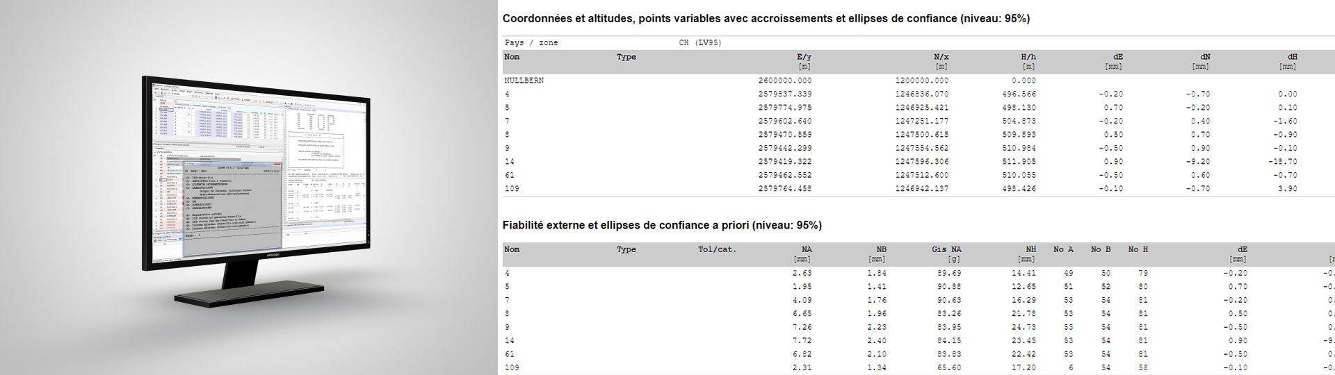
Präanalyse- und Ausgleichungssoftware für geodätische Netze
LTOP bietet eine Vielzahl von Berechnungsmöglichkeiten und Indikatoren an, um die Ausgleichung zu optimieren und Fehler oder Ungenauigkeiten festzustellen. Die Beobachtungen können vermittelnd nach der Methode der kleinsten Quadrate oder robust ausgeglichen werden.
In GeoSuite wurde ein neues grafisches Interface integriert, die die Eingabe von Parametern für eine LTOP-Berechnung deutlich vereinfacht.
Möglichkeiten und Eigenschaften Lage- und Höhenausgleichung werden getrennt durchgeführt (2D+1D) Freie Ausgleichung, Koordinaten der Anschlusspunkte (AP) als Beobachtungen oder gezwängte (definitive) Ausgleichung Berechnung, die auf ebenen Koordinaten (Projektionssystem) oder geografischen Koordinaten auf einem Ellipsoid basiert Für Richtungen, Azimute und Distanzen sind je maximal 80 Gruppen mit individuellen Orientierungs- resp. Massstabs- und Additionsunbekannten möglich: a-z A-Z 0-9 ! # $ % & * : ; < = > ? @ _ | ~ + - Mehrere mögliche Parameterkombinationen für die Integration von GNSS-Sätzen Strenger Genauigkeits- und Zuverlässigkeitsnachweis sowie entsprechende Tests für die amtliche Vermessung Grafische Darstellung von Vermessungsnetzplänen und Ergebnissen des Netzausgleichs (Planimetrie und/oder Altimetrie)
Weiterführende Informationen
Links
GeoSuite (LTOP/REFRAME/TRANSINT)
BSD 3-Clause License
Copyright © 2025, swisstopo. All rights reserved.
Redistribution and use in source and binary forms, with or without modification, are permitted provided that the following conditions are met:
- Redistributions of source code must retain the above copyright notice, this list of conditions and the following disclaimer.
- Redistributions in binary form must reproduce the above copyright notice, this list of conditions and the following disclaimer in the documentation and/or other materials provided with the distribution.
- Neither the name of the copyright holder nor the names of its contributors may be used to endorse or promote products derived from this software without specific prior written permission.
THIS SOFTWARE IS PROVIDED BY THE COPYRIGHT HOLDERS AND CONTRIBUTORS «AS IS» AND ANY EXPRESS OR IMPLIED WARRANTIES, INCLUDING, BUT NOT LIMITED TO, THE IMPLIED WARRANTIES OF MERCHANTABILITY AND FITNESS FOR A PARTICULAR PURPOSE ARE DISCLAIMED. IN NO EVENT SHALL THE COPYRIGHT HOLDER OR CONTRIBUTORS BE LIABLE FOR ANY DIRECT, INDIRECT, INCIDENTAL, SPECIAL, EXEMPLARY, OR CONSEQUENTIAL DAMAGES (INCLUDING, BUT NOT LIMITED TO, PROCUREMENT OF SUBSTITUTE GOODS OR SERVICES; LOSS OF USE, DATA, OR PROFITS; OR BUSINESS INTERRUPTION) HOWEVER CAUSED AND ON ANY THEORY OF LIABILITY, WHETHER IN CONTRACT, STRICT LIABILITY, OR TORT (INCLUDING NEGLIGENCE OR OTHERWISE) ARISING IN ANY WAY OUT OF THE USE OF THIS SOFTWARE, EVEN IF ADVISED OF THE POSSIBILITY OF SUCH DAMAGE.
Applikationen - Download
LTOP
Installationspaket -Version 99.6 für Windows (Linux-Version auf Anfrage)
Inhaltsverzeichnis
Bundesamt für Landestopografie swisstopo
Seftigenstrasse 264
3084 Wabern