
Alexandre Stryienski: a topographer in the vortex of continental politics
Alexandre Stryienski was born in 1804 in Białystok, Prussia, rebelled against Russian rule in Poland and surveyed Swiss landscapes from 1833. How did this remarkable life come about?
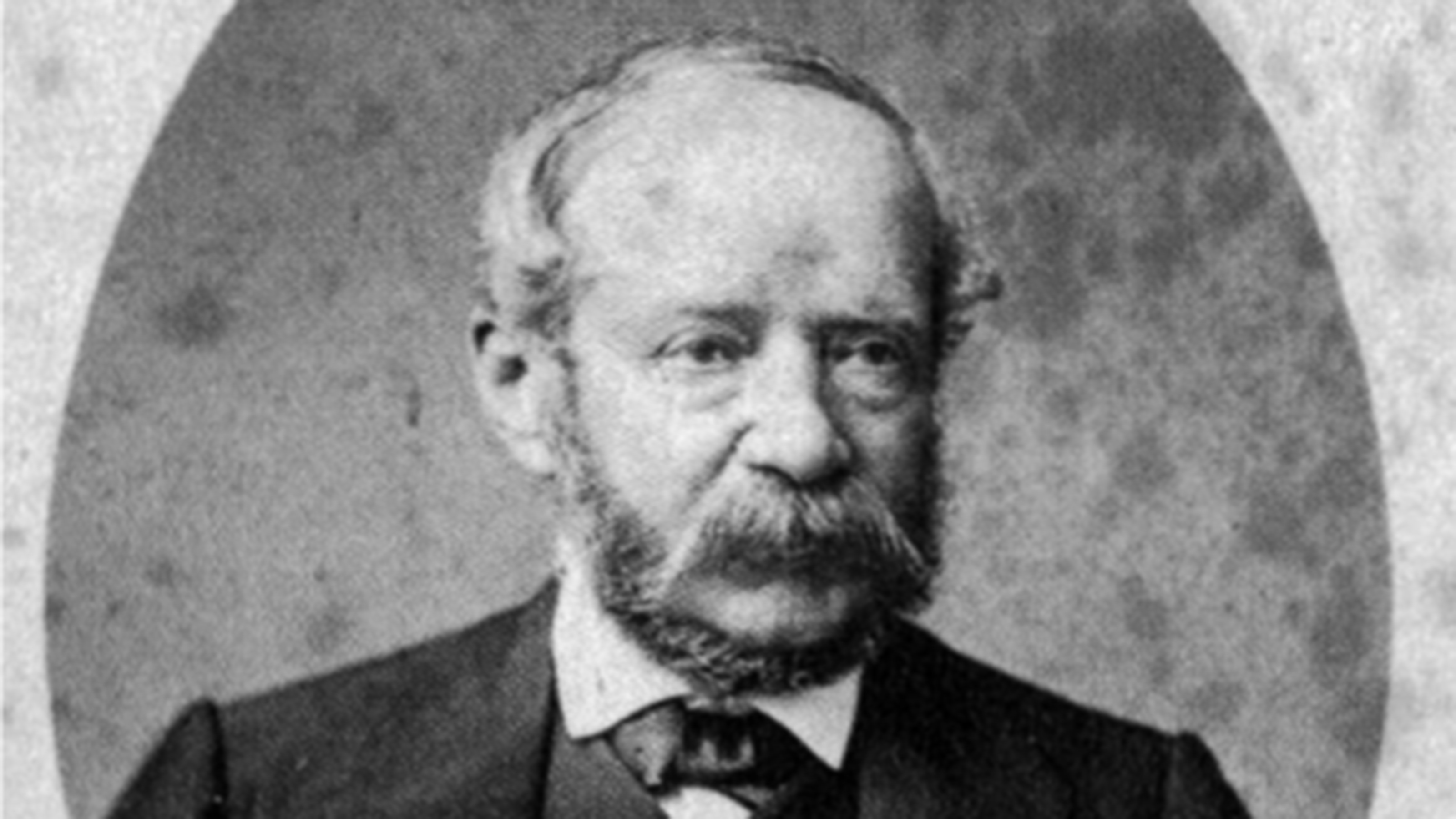
In 1855, the Carte topographique du canton de Fribourg was published to a scale of 1:50,000. A Polish immigrant with an impressive name contributed significantly to this landmark of Swiss cartography: Alexandre Casimir Napoleon Stryienski (1804-1875) carried out topographic surveys of the canton of Fribourg between 1844 and 1852. The results of this work were also incorporated into sheet XII Freyburg, Bern of the Topographic Map of Switzerland (Dufour Map). To understand why an Eastern European topographer surveyed French-speaking Switzerland, it is necessary to explore his eventful biography.
A topographer, from the Tsarist Empire to the Swiss Confederation
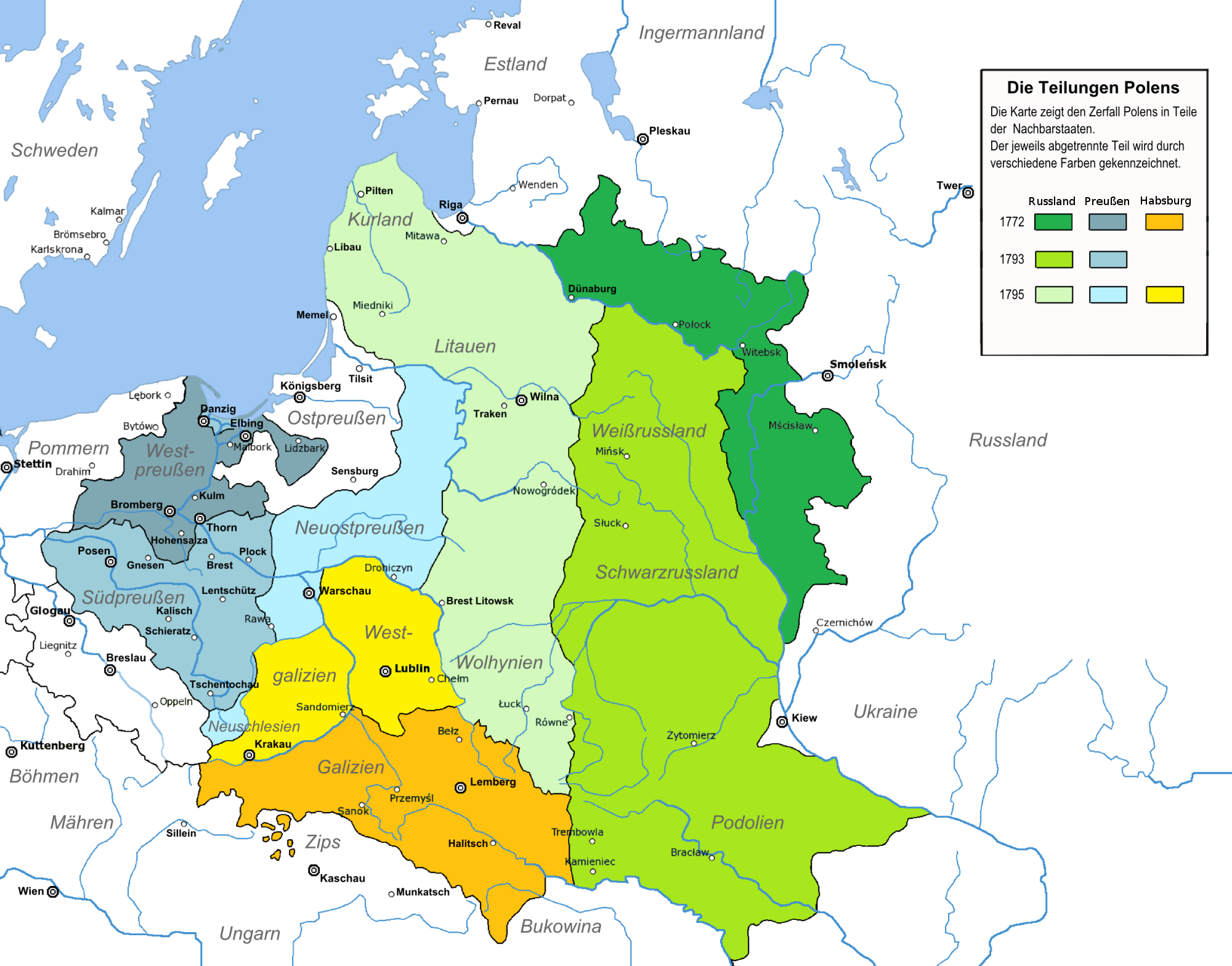
Alexandre Stryienski's emigration to Switzerland is closely linked to the dramatic situation concerning the Polish state (Poland-Lithuania) in the 18th century. In 1772, 1793 and 1795, Prussia, Austria and Russia divided up the territories of their neighbouring state amongst themselves which had been weakened by internal unrest and wartime defeats. The third partition of 1795 sealed the dissolution of Poland-Lithuania; only in 1918 was there to be an independent Polish state again.
Alexandre Stryienski's life story was shaped by the partitions of Poland. Born in Białystok in 1804, he grew up in the Russian Empire and carved out a successful career for himself. According to the Fribourg geologist Marino Maggetti, Stryienski trained as a military engineer at the cadet school in Warsaw. Because Warsaw, like Białystok, was under Russian rule at the time, Stryienski moved with the Tsar's army in 1828 to what is now Bulgaria, where he took part in the Russo-Turkish War. For his service, he was promoted to the position of captain in the Russian general staff.
Despite his military advancement, Stryienski decided to take part in the November Uprising in 1830/31 which strove to secure Poland's independence from Russia. The uprising became a turning point in the life of the topographer and military man: the rebellion failed and Stryienski was sentenced to death in absentia. Like many other members of the Polish upper class, he fled to France after the failed uprising, and in 1833 he moved from there to Switzerland.
At the service of the canton and the Confederation
Despite the abrupt break in his career, Alexandre Stryienski was able to gain a foothold in his new homeland. As was customary among the Polish nobility at the time, he spoke fluent French and, thanks to his education, was soon able to establish himself as a surveyor in French-speaking areas of Switzerland. Between 1833 and 1839, Stryienski produced, among other things, six forest maps of the Jura on behalf of the canton of Bern, before taking up activities that secured him a place in Swiss cartographic history: in 1838, Stryienski moved to Carouge near Geneva, where from then on, he worked at the Federal Topographical Bureau and as an employee of the Geneva cantonal administration. From 1839-41, he was commissioned by Guillaume Henri Dufour to carry out surveys in the canton of Valais; in 1843/44, parallel to his work at the federal level, he entered the service of the cantons of Fribourg and Vaud.
In 1847, the canton of Fribourg provided Stryienski with an assistant, Neuchâtel engineer Henri d'Hardy, who also carried out topographic surveys. The surveying work by the two men not only made possible the Carte topographique du canton de Fribourg, but also contributed to sheet XII Freyburg, Bern of the Dufour Map.
Alexandre Stryienski's work between the Confederation and the cantons was typical of the work on the Dufour Map. Most of the cantons of the Swiss Central plateau surveyed their territory themselves and received federal subsidies for doing so. This was on the condition that the original surveys were sent to the Federal Topographic Bureau in Carouge, where they served as the basis for the production of the Dufour Map, the first official map series for the whole of Switzerland. Stryienski's career in Switzerland exemplifies this win-win situation between the Confederation and the cantons, which were still sovereign until 1848. He spent most of the winter months at the Federal Topographical Bureau in Carouge, while spending the summer doing surveying work in the cantons of Vaud and Fribourg. His letters also bear witness to this: Stryienski moved between Carouge, Vaud and Fribourg depending on the season.
A homeland lost and a homeland gained
Alexandre Stryienski experienced a meteoric rise in the Swiss Confederation. Only five years after fleeing to Switzerland via France, he was one of the first employees of the Federal Topographical Bureau in 1838. By 1860, his topographic surveys had been incorporated into two sheets of the Dufour Map and served as the basis for the Fribourg cantonal map.
As one of the first employees of the Federal Topographic Bureau, Stryienski worked at the nucleus of today's Swiss national triangulation network. The fact that Stryienski was aware of this special honour is suggested in the way he signed his letters, not only mentioning the municipality where he had written it, as was usually the case, but also the house: Guillaume Henri Dufour had founded the Federal Topographical Bureau in 1838 at the Maison Chossat in Carouge. The fact that he wrote his letters at the heart of Swiss cartography was regularly emphasised by Stryienski. More subtly, however, he also emphasised his Polish origin by adding the Polish nasal sound "ń" to his surname.
However, it is Stryienski's twilight years in particular that bear witness to the fact that the rebel of 1830/31 had never forgotten his first homeland. He was committed to helping Polish refugees who, like Stryienski himself thirty years earlier, had found refuge in Switzerland after another uprising against Russian rule in 1863/64.
Global Swiss cartography
Switzerland's official cartography was already intertwined with the world in its early years and made extensive use of foreign knowledge and experts. Guillaume Henri Dufour trained as an engineer geographer in Paris, his engravers came from France and South Tyrol, and Alexandre Stryienski, a nobleman who had fled from what was then Russia, worked for the Bureau. Although cantonal and national maps depicted clearly delineated territories, the people, instruments and skills behind these maps testify to just how international national cartography was and is.
Links
Federal Office of Topography swisstopo
Seftigenstrasse 264
3084 Wabern