
More information, more precision
The political, economic and military spheres of the thriving Federal State needed increasingly precise maps in order to keep up-to-date with the spatial factors of the Confederation. The “Swiss Topographical Atlas” (Siegfried Maps) answered this need. Its total of 604 sheets were published between 1870 and 1926 to a scale of 1:25'000/1:50'000.
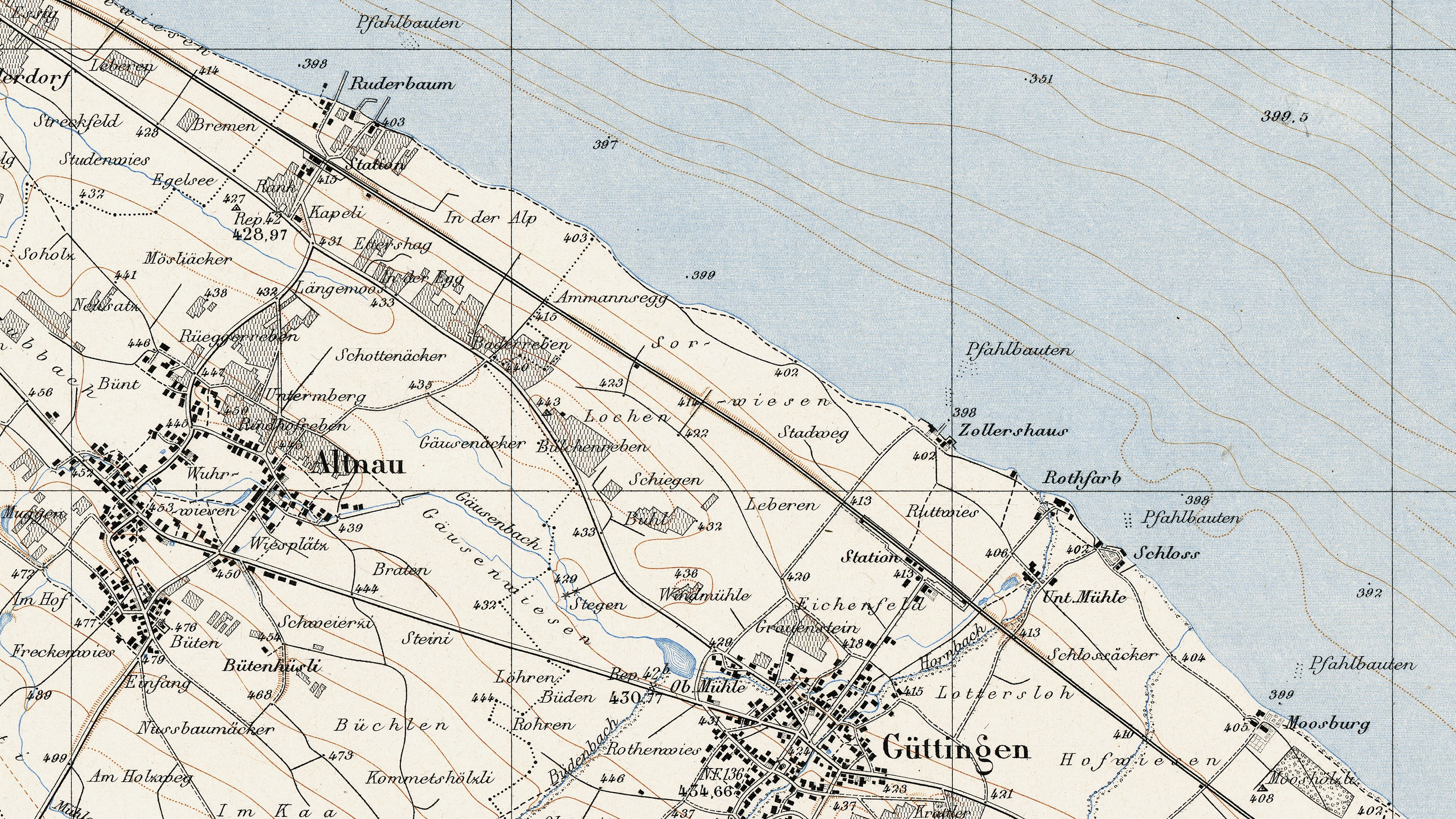
The Siegfried Map
The Dufour Map was a masterpiece of surveying and cartography. But the young Federal State soon developed new needs: a booming economy, a growing network of infrastructure and an administration, which was constantly covering new areas of human interaction, needed ever more precise spatial information.
In 1868, three years after the Dufour Map was completed, Parliament established the legal basis for a new map to meet the new challenges. The “Swiss Topographical Atlas”, also known as the Siegfried Map, showed Switzerland to a larger scale than the Dufour Map: 1:25 000 (Swiss Central plateau) and 1:50 000 (Alps and Jura).
It thus offered a lot more space in order to integrate information about topography, residential settlements, infrastructure and rock formations into the map. The newly added contour lines and tricolour printing further increased the informative value of this second Swiss map.
Geodetic points and Heights
The Siegfried Map sheets were published over a period of almost 60 years. Many important changes occurred in Swiss national topography during this time. These developments can be summed up by an increase in precision and new technological processes.
Three base line measurements 1880/1881, the LV03 national triangulation network (1903–1939) and two levellings (1865–1883, 1903–1927) determined the geodetic surveying points and the altitudes in Switzerland with increasing precision.
The constant improvement of altitude measurements is also reflected in the fact that the Swiss height reference point in the harbour of Geneva was redefined: It “sank” from 376.86 to 373.6 metres over the Marseille water level.
Photographic Processes
Like the altitudes, which were only included in the National Maps following their redefinition, topographical surveying methods also evolved.
After the First World War, work at the surveying table increasingly gave way to photographic processes: the topographers took stereo pairs from the ground, which they could then process in their offices. This “photogrammetric process” developed over the following decades into a key technology for surveying Switzerland.
1867: Publication of first sheet of general map
Publication of first sheet (no. II) of the 1:250,000 general map.
1868: Adoption of legislation governing continuation and publication of original surveys
Swiss Alpine Club successfully campaigns for adoption of legislation governing the continuation and publication of the original surveys.
1870: Publication of the 13 first sheets of the topographic atlas
Publication of the first 13 sheets of the 1:25,000 and 1:50,000 topographic atlas (Siegfried Map).
1878: Publication of overview map
Publication of 1:1 million overview map.
1879: Calculation of altitude of R.P.N. control point by Siegfried
Hermann Siegfried calculates the altitude of the R.P.N. control point in Geneva as the starting point for height measurement based on precision levelling elements (but with the previous reference height of the Chasseral dating from 1840) as 376.86 metres above sea level (also referred to as "old horizon"). This figure is applicable for all published sheets of the Siegfried Map.
1880: Aarberg base line measurement
Aarberg base line measurement by Spanish General Ibañez as part of the central European arc measurement.
1887: First maps with relief shading
Publication of first maps with relief shading (Oberland I and Jaun-Thun sheets, 1:50,000).
1898: Systematic surveys of the national borders
Commencement of systematic surveys of the national borders.
1902: Calculation of altitude of R.P.N. control point by Jakob Hilfiker
Altitude of R.P.N. control point in Geneva calculated by Jakob Hilfiker (based on associated levellings from abroad) as 373.6 metres above sea level (referred to as "new horizon" and used as initial height for the national map). Starting point is mean sea level of Marseille (France).
1903: First national levelling
Commencement of first national levelling (until 1927).
1903: Proposal for conformal projection
Max Rosenmund proposes oblique, conformal cylinder projection for surveying Switzerland (= CH1903).
1909: Federal resolution on land register survey
Federal resolution on the land register survey (in conjunction with the Swiss Civil Code that entered into force in 1912).
1910: Changeover from lithography stone to copper plate
Initiation of transfer of production of mountain map sheets from lithography stone to copper plate.
1912: Introduction of offset printing
Introduction of offset printing. First own machine supplied by George Mann (Leeds, UK).
1912: Entry into force of Swiss Civil Code
Entry into force of the Swiss Civil Code, which calls for the creation of a land register with corresponding plans.
1913: Petition for a 1:25,000 map
Swiss Geological Commission petitions Federal Council for a 1:25,000 map of the entire country.
1926: Recruitment of first pilots
Recruitment of first pilots for aerial images. Oblique images photographed by hand from open aircraft (Zepp C.II). Instruments provided by Zeiss.
1926: Introduction of terrestrial photogrammetry
Definitive introduction of terrestrial photogrammetry in the Alps. Acquisition of two valuation instruments and four cameras supplied by Wild.
1926: Publication of last sheets of "Siegfried Map"
A total of 604 sheets of the Siegfried Map have been published: last sheet to appear, 274bis Gaschurn.
Federal Office of Topography swisstopo
Seftigenstrasse 264
3084 Wabern