
Published on 8 January 2024
FAQ
Frequently asked questions concerning geodesy, surveying and navigation.
Why does a ship disappear on the horizon or what influence do the curvature of the earth and refraction have on horizontal visibility?
For a distance (D) of 349 kilometres (width of Switzerland from east to west), the apparent height difference due to terrestrial curvature (E) and refraction (R) would be -8318 metres. Refraction here means the refraction of the light beam in the lowest part of the earth's atmosphere as a result of the decreasing air density with height. This beam curvature is on average 13% of the curvature of the earth and increases the horizontal visibility to a small extent.
The illustrated example shows the commonly known effect of the apparently disappearing ship on the horizon of a large lake with increasing distance from the point of observation.
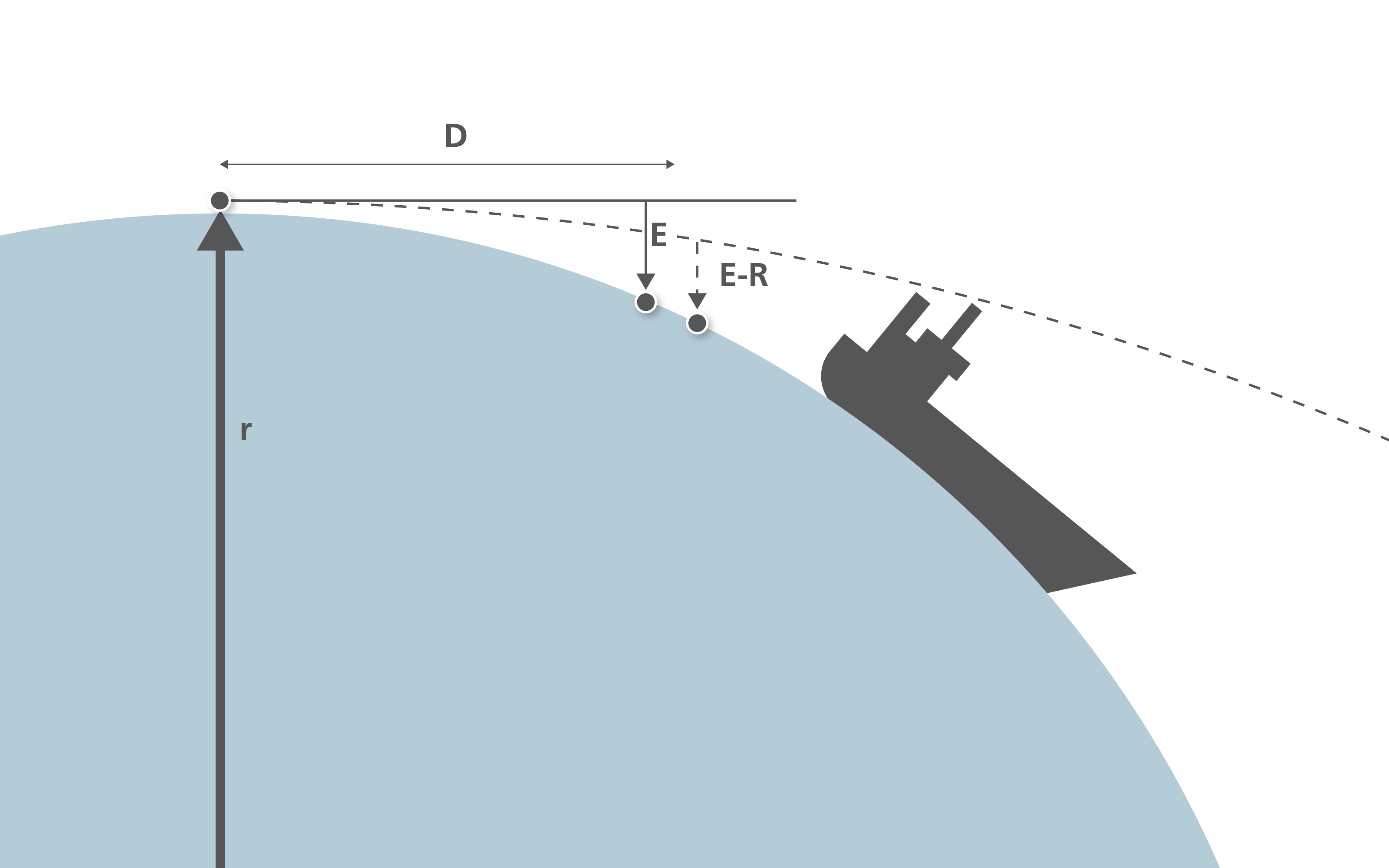
Terrestrial curvature D [km] E[m] E-R[m] Remark
1 0.08 0.07
10 7.8 6.8
100 780 680
221 3834 3335 Switzerland: N-S
349 9560 8318 Switzerland: E-WFormula
E = D*D / 2r
E-R = 0.87 * D*D / 2r
The figure of 6370 kilometres was used for the earth's radius.
The figure 0.87 is obtained from 1 minus the refraction coefficient (~0.13).
What entries must be made in the GPS device so that Swiss national coordinates, as shown on our national maps, are displayed directly?
Select in the GPS device:
- Reference system «CH1903» and
- map projection (grid) «SWISSGRID».
On which website can the geographical coordinates (longitude and latitude in degrees and angular minutes and possibly seconds) of the Swiss cities be found?
The desired information can be found at www.map.geo.admin.ch: Enter the name of the city, click on the marker; the coordinates are displayed in the small «Object information» window.
The online service NAVREF can be used to transform national coordinates into geographic coordinates and vice versa.
The geonames.org database contains place names and their geographical coordinates from all over the world.
How can geographical coordinates (latitude / longitude / ellipsoidal height) be converted from WGS84 to Swiss national coordinates in LV95 (y / x / H) and vice versa?
a) Manual input of single points:
On the following web page the NAVREF software is available online for conversion in the metre range:
b) Entering coordinate files for conversion with greater accuracy:
On the following web page a series of points can be transformed online into all applicable reference systems and reference frames in Switzerland, using several common data formats:
Where is the geographical centre of Switzerland?
If you precisely measure on the 1: 25 000 national map or look for the coordinates with a GPS device outside, you will find the point directly above the rock face to the west of Chli Aelggi in the municipality of Sachseln in the canton of Obwalden. But this site is practically inaccessible. In view of this, the marking of the centre of Switzerland was therefore moved 500 metres to the south-east.
The Sachseln Corporation made the ground on the small hilltop available free of charge for this marking. swisstopo donated a triangulation pyramid and the Sachseln Steinmanndli Club built a wall in the shape of Switzerland around the pyramid.
An aluminium panel was installed with a map of Switzerland showing the geographic centre in all directions in the respective national languages.
Where is the centre of the biggest possible circle within Switzerland that touches the border but does not cross it at any point? The centre of this circle is actually the point that is located furthest from our neighbouring countries.
swisstopo has calculated the point furthest from the border. This is located in the municipality of Uetendorf in the canton of Bern. And to be precise: The furthest point of our country from the border can be found on a field with the field name Silbermoos; it has the coordinates 2,610,170 / 1,181,300.
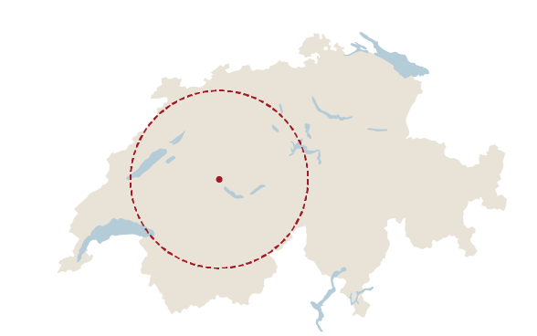
With help of geographical information systems, this point can be precisely determined. You go from the border and draw parallel lines at an ever-greater distance from the border. The point you are looking for is located in the last remaining area. This process is illustrated in the following drawing.

What is the starting point for height measurements in Switzerland?
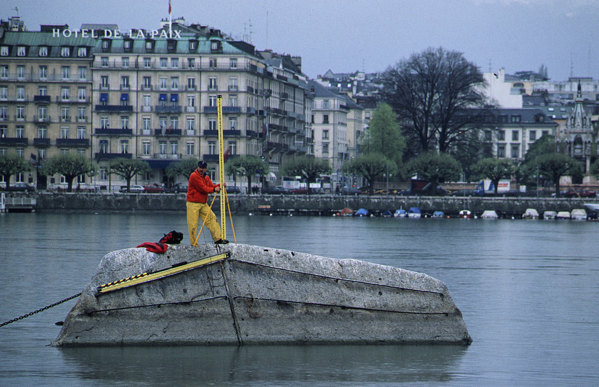
The reference for all height measurements in Switzerland is «Repère Pierre du Niton» in the harbour of Geneva. It is used for all surveying and maps in Switzerland.
Its original height, the «old reference», 376.86 metres above the mean sea level of the Mediterranean (tide gauge in the harbour of Marseilles) was determined in the 19th century based on the height of Mount Chasseral, which had been determined inaccurately by French engineers and geographers from the tide gauge in Marseilles. This original height was used for the old height observations (precise levelling, 1864 to 1891) as well as for the Dufour and Siegfried Maps.
At the beginning of the 20th century, within the scope of the national survey, this reference was recalculated. In 1902, a study by J. Hilfiker was published in which the height of «Repère Pierre du Niton» was computed from different tide gauges in Europe. The official figure of 373.6 metres (i.e. the «new reference») was introduced in 1902 and was 3.26 metres lower than the old reference height.This value should subsequently be valid for the national levelling (LN02), the national surveys (LV03 and LV95) and all surveys in Switzerland.
The new horizon was only gradually implemented across the whole of Switzerland in the form of the height frame «LN02» with the «new» national levelling 1902-1927. The national maps and all parcel surveys created after the introduction of the Swiss Civil Code are also based on this horizon.
The old heights, i.e. in the Siegfried Map, are therefore 3.26 metres above the official heights in the national maps and in all cadastral plans in Switzerland. Despite concerted efforts to inform professional organisations of this change, the implementation of the new height progressed very slowly, especially in civil engineering and the construction industry, and this has often led to errors and confusions concerning heights.
Definition of the 1902 reference
- Controlled via four connections to sea level
- Obtained from the tide gauge in Marseilles and rounded to 373.6 metres above sea level
Repère Pierre du Niton applications
New reference Old reference
since 1902 before 1902
- Precise levelling - Precise levelling
(LN02)
- National control survey - Dufour Map
(LV03)
- Cadastral survey - Siegfried Map
- National maps- Controlled via four connections to sea level
What does «reference system» mean in geodesy?
The earth has a very complex shape, it resembles a potato. This shape is not suitable as a mathematical reference surface. It is therefore simplified: The earth is represented as an ellipsoid and provided with a coordinate system that designates longitudes, latitudes and altitudes above the ellipsoid.
The reference system defines the size, shape and position of an ellipsoid. References for this are the centre of the earth, the earth's axis and the Greenwich meridian. All coordinates are based on a defined reference system.
Different countries use different national ellipsoids and reference systems for practical and historical reasons.
Modern satellite-based measuring methods are based on globally applicable reference systems. GPS, for example, uses the World Geodetic System 1984 (WGS84). The local Swiss reference system is labelled CH1903+.
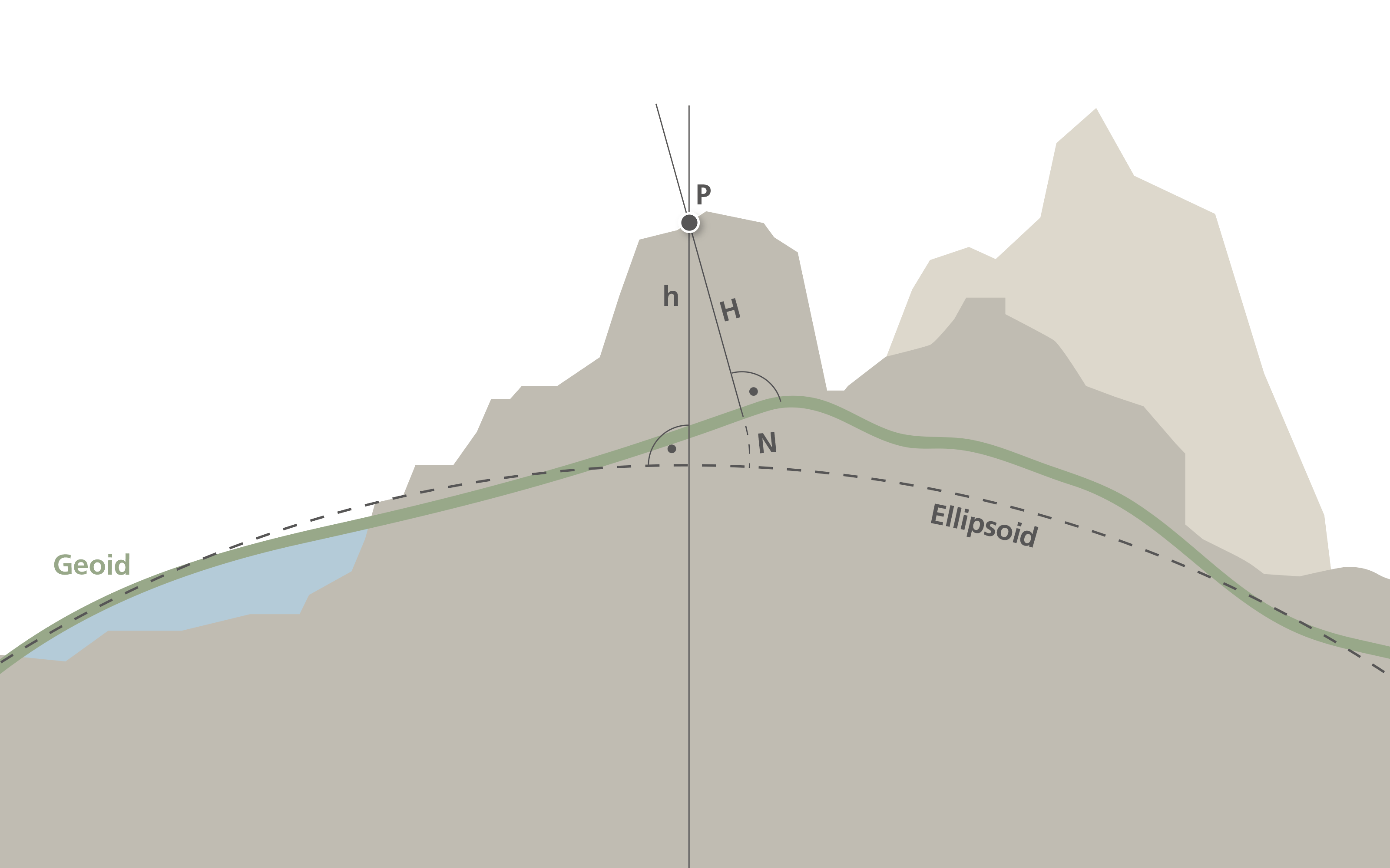
Graphic of a Geoid and Ellipsoid What does «projection system» mean in geodesy?
A projection system attempts to map the earth's surface, or at least part of it, onto a flat surface. Due to the curvature of the earth in all directions, this is only possible with restrictions. An orange peel cannot easily be spread out flat on a table without any gaps.
In practical use, flat and rectangular coordinates are used. Longitudes and latitudes, the «bent» geographical coordinates of the reference system, are not very suitable. A rectangular coordinate grid is created by projection, i.e. by mapping the ellipsoid onto a strictly geometric body such as a sphere, cylinder, cone and plane or a combination of these.
In the official Swiss projection system, points on the earth's surface are transferred to a cylinder, resulting in the «oblique, true-angle cylindrical projection». The point of contact between the cylinder and sphere corresponds to the zero point of the coordinate system. It is located at the old observatory in Bern. By mentally unrolling the cylinder, the desired image of the earth is created on a surface.

Oblique, conformal cylinder projection What does «reference frame» mean in geodesy?
The theoretical definition of a reference and a projection system (see corresponding FAQs) alone is not sufficient for carrying out surveying work. Fixed points distributed throughout Switzerland or permanently operated satellite measuring stations and their precisely determined coordinates form the so-called reference frame. All spatial data, for example data from the areas of cadastral surveying, supply and disposal, spatial planning, construction, but also data from a geographical information system, are fitted into this frame and geometrically related.
In order to fully utilise the advantages of GNSS technology - in particular the positioning services - Switzerland's almost 100-year-old reference frame LV02 was renewed at the end of the last century between 1989 and 1995 as part of the national survey and connected to the European reference system via the fundamental station in Zimmerwald. The fixed points of the LV95 reference frame, which were set and measured in the process, guarantee a satellite-based, highly accurate and consistent base network.
Automatically operated satellite measuring stations and the positioning services based on them are also used to determine precise coordinates and heights in real time. The basis for this is the Automatic GPS Network Switzerland (AGNES) with its 40 permanently operated stations nationwide and the positioning services swipos-NAV and swipos-GIS/GEO as well as the GNSS reference network with approx. 200 fixed points distributed throughout Switzerland. In addition to these federal positioning services, similar services are also offered by private organisations.
The reference system and the map projection were retained for the LV95 reference frame. The coordinate axes are labelled E (East, formerly y) and N (North, formerly x) so that the coordinates of the current reference frame can be clearly distinguished from those of the previous reference frame. The zero point of the national coordinate system corresponds to the values E0 = 2 600 000 000 m and N0 = 1 200 000 000 m.

Image of Switzerland with the new coordinates