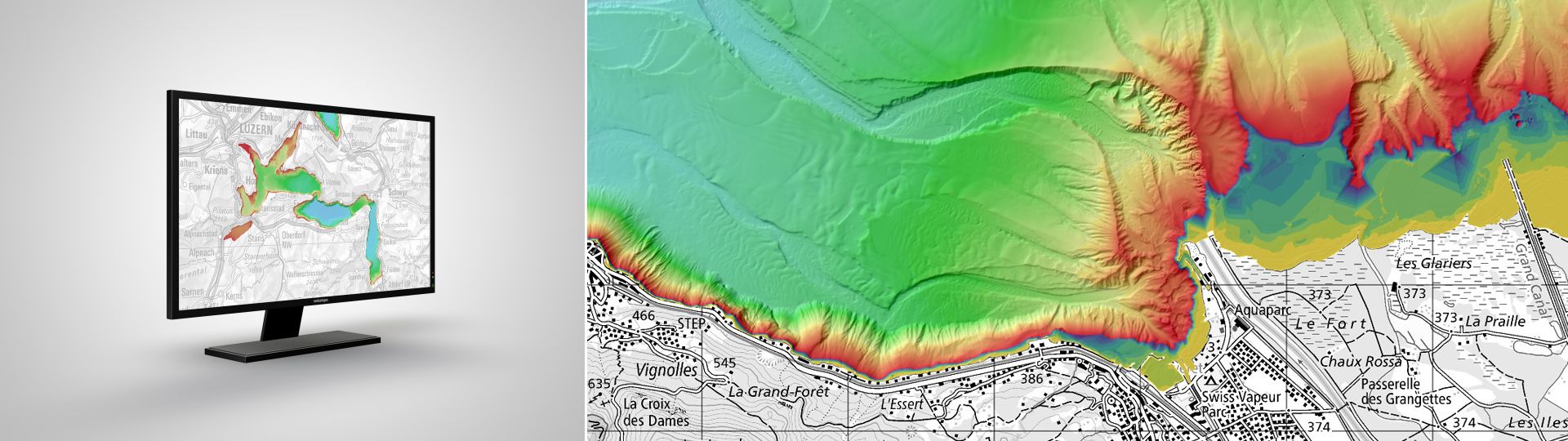
swissBATHY3D contains bathymetric data in the form of a very accurate digital elevation model that describes the topography of the Swiss lakebeds.
Bathymetric data of Swiss lakes
The bathymetric data are acquired by a collaboration between cantons, universities, the Swiss Confederation and sometimes other public institutions from neighboring countries.
swissBATHY3D is a digital terrain model of the Swiss lakebeds. The measurements of this model correspond to an elevation in a Swiss coordinates system and not to a depth relating to water levels of the lakes.
Applications
swissBATHY3D is suitable for specific applications such as :
Planning and implantation of underwater constructions
Structure
Data are only available in the full ground resolution (see technical details by lake) in the 2 following data formats :
ASCII X,Y,Z single space
ESRI ASCII GRID
Data are tiled in tiles of 1 km2. Only complete tiles are delivered. The filename of the delivered files contains the X and Y coordinates in kilometers of the south-west corner of tiles.
Altimetric accuracy : +/- 0.5 m (1 sigma). This accuracy strongly depends on the water depth. It gets better to 0.1-0.2 m for the shallowest parts et can reach 1 m for the deepest parts.
The sample data show their type and format. They are free of charge and can be used for test purposes only. It is not allowed to include them in a product.
Data coverage : The entire lake and a part of the shores are covered. A few holes in the data have been left empty (no data).
Available area : 7 km2
Ground resolution : 1 m
Data status : 2015
Data coverage : The entire lake and a part of the shores are covered. A few holes in the data have been left empty (no data).
Available area : 5 km2
Ground resolution : 1 m
Data status : 2023
Data coverage : The entire lake and a part of the shores are covered.
Available area : 45 km2
Ground resolution : 1 m
Data status : 2015, 2016
Data coverage : The entire lake and a part of the shores are covered. A few holes in the data have been left empty (no data).
Available area : 29 km2
Ground resolution : 1 m
Data status : 2018, 2019
Data coverage : The entire lake and a part of the shores are covered. A few holes in the data have been left empty (no data).
Available area : 605 km2
Ground resolution : 3 m
Data status : 2013, 2014
Data coverage : In the French part of the lake, only the areas with a minimal water depth of about 5 m are covered. In the Swiss part, the entire lake is covered.
Available area : 576 km2
Ground resolution : 2 m
Data status : 2012, 2013, 2016
Data coverage : The entire lake and a part of the shores are covered. A few holes in the data have been left empty (no data).
Available area : 10 km2
Ground resolution : 1 m
Data status : 2022
Data coverage : The entire lake and a part of the shores are covered. A few holes in the data have been left empty (no data).
Available area : 10 km2
Ground resolution : 1 m
Data status : 2018, 2022
Data coverage : The entire lake and a part of the shores are covered. A few holes in the data have been left empty (no data).
Available area : 114 km2
Ground resolution : 1 m
Data status : 2007, 2014,2018,2023,2024
Data coverage : Only the areas with a minimal water depth of about 5 m are covered.
Available area : 2 km2
Ground resolution : 1 m
Data status : 2023
Data coverage : Only the areas of the Swiss part of the lake with a minimal water depth of about 1.5 m are covered. A few holes in the data have been left empty (no data).
Available area : 68 km2
Ground resolution : 1 m
Data status : 2022
Data coverage : The entire lake and a part of the shores are covered. A few holes in the data have been left empty (no data).
Available area : 32 km2
Ground resolution : 1 m
Data status : 2012, 2016, 2022
Data coverage : The entire lake and a part of the shores are covered. A few holes in the data have been left empty (no data).
Available area : 242 km2
Ground resolution : 1 m
Data status : 2012, 2016, 2020
Data coverage : The entire lake and a part of the shores are covered. A few holes in the data have been left empty (no data).
Available area : 7 km2
Ground resolution : 1 m
Data status : 2023
Data coverage : The entire lake and a part of the shores are covered. A few holes in the data have been left empty (no data).
Available area : 14 km2
Ground resolution : 1 m
Data status : 2023
Data coverage : Only the areas with a minimal water depth of about 2 m are covered.
Available area : 5 km2
Ground resolution : 1 m
Data status : 2019
Data coverage : Only the areas with a minimal water depth of about 1 m are covered.
Available area : 4 km2
Ground resolution : 1 m
Data status : 2019
Data coverage : The entire lake and a part of the shores are covered. A few holes in the data have been left empty (no data).
Available area : 49 km2
Ground resolution : 1 m
Data status : 2014, 2019
Data coverage : Only the areas with a minimal water depth of about 2 m are covered.
Available area : 24 km2
Ground resolution : 1 m
Data status : 2020
Data coverage : The entire lake and a part of the shores are covered. A few holes in the data have been left empty (no data).
Available area : 39 km2
Ground resolution : 1 m
Data status : 2016
Data coverage : Only the main lake between Zurich and Rapperswil is covered (no data on the Obersee). Only the areas with a minimal water depth of about 5 m are covered. A few holes in the data have been left empty (no data).