Open print view

Aerial Photographs

These aerial photographs are analogue images which are scanned and delivered exclusively in digital form.

aerial_images_digital

Scanned analogue images
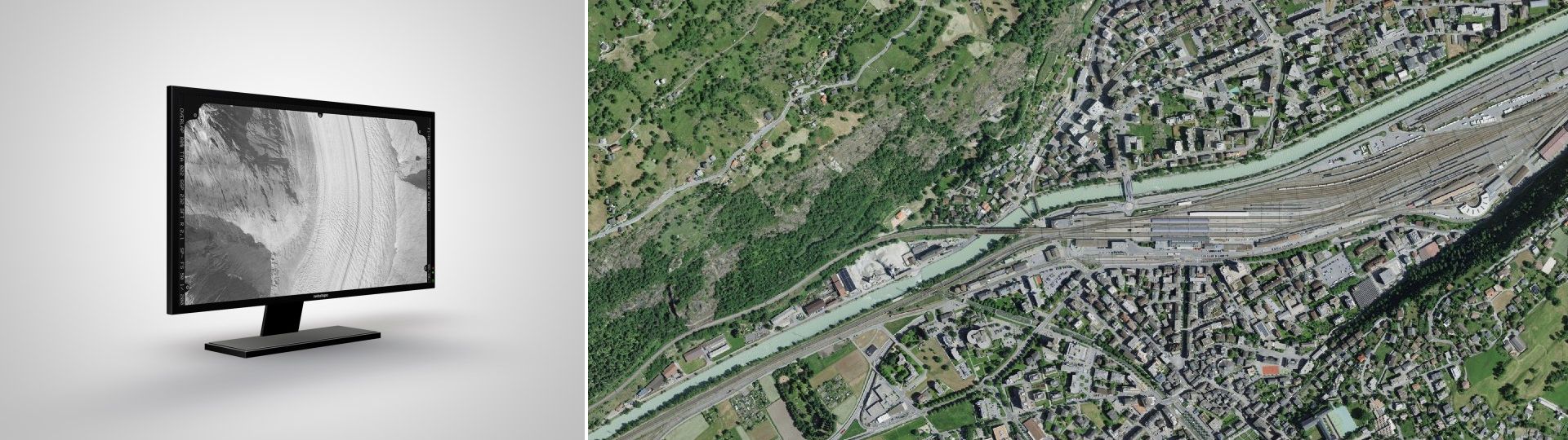
Aerial photographs are analogue images that are scanned and are provided exclusively in digital form. You can find detailed information about the aerial photographs under Image collection. With the LUBIS Viewer application, you can search, display and order all terrestrial images, aerial photographs and aerial image strips which are registered in swisstopo’s LUBIS aerial imagery information system.
Analogue aerial photographs of the entire country are available for the years up to and including 2007. You can find more recent photographs from 2008 onwards in the SWISSIMAGE product.
Around 108'000 of the aerial photographs in swisstopo’s image collection come with orientation elements and a single-image orthophoto. You can find out whether these are available by looking at the additional information for your chosen aerial image in the LUBIS Viewer.
Depending on availability, the product “aerial images” includes the following data:

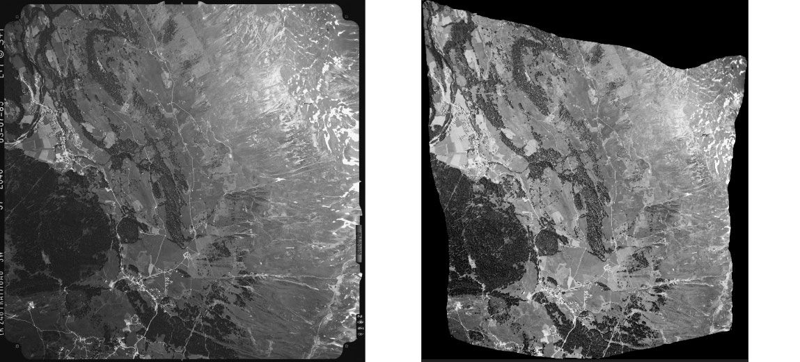
  • Scanned aerial image
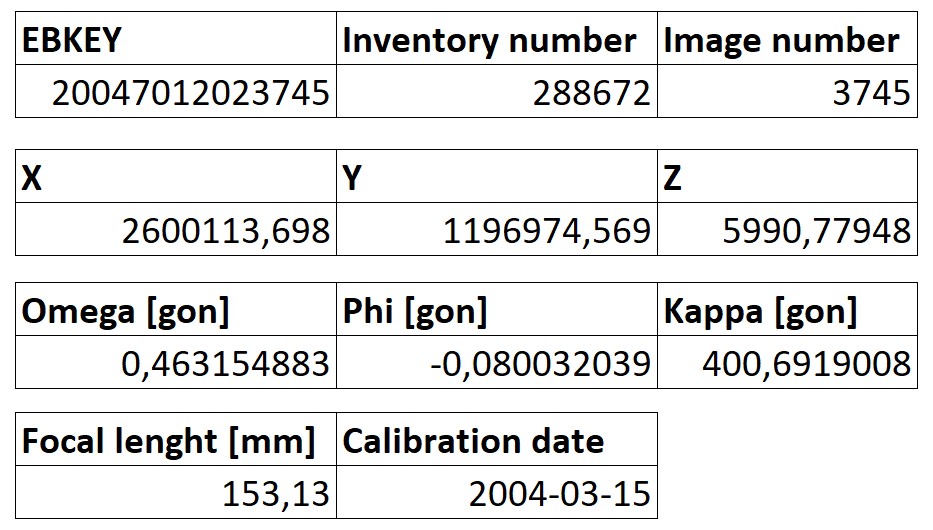
  • Data sheet
  • Orientation elements
  • Single-image orthophoto

Applications

  • As a basis for studies of the development of landscapes and housing
  • For nature and environmental research purposes
  • As a basis for planning and development
  • For the identification of contaminated sites
  • To provide a time-series of images
  • For general documentation
  • As a wall decoration or an attractive gift

Price and ordering

The dataset is not available for free download. Please send your orders to geodata@swisstopo.ch who will make an offer for the costs of the provision of the data.
To make ordering easier, please mention the image numbers found in the  LUBIS Viewer .

Terms of use

Additional information

Technical details

Aerial image

  • Data per photo: ca 270 MB (b/w) 1 channel, ca 830 MB (color) 3 channels (RGB)
  • Scan resolution: 23 x 23 cm 14 µm (1814 dpi),  ≤18 x 18 cm 21 µm (1210 dpi)
  • Data format: Tiff, 8 bit  per channel 

Data sheet

txt file containing all the attributes shown in the LUBIS viewer. 

Orientation elements

In order to be able to make use of measurements on aerial images, it is necessary to reconstruct the position and orientation of the image at the moment of exposure. For this purpose we provide the required orientation elements, describing the outer orientation of the camera. The coordinates x, y and z (since 2023 in the coordinate system CH1903+/LV95 LN02) are those of the projection centre of the camera and the angles Phi, Omega and Kappa indicate its direction.

Exemple d'un jeu d'éléments d'orientation

The orientation elements shown above are available for around 108'000 of the aerial images from swisstopo’s image collection. When you purchase an aerial image, you will also receive the accompanying orientation elements free of charge.

The geometric properties of the camera constitute the inner orientation and are shown in the relevant calibration certificate (see documents).

Single-image orthophoto

  • The resolution is 0.5 or 1m depending on the image scale.
  • Orthophotos are created using the latest version of swissALTI3D. The positional accuracy is 2 to 4 pixels.
  • Data per photo: ca 270 MB (b/w) 1 channel, ca 830 MB (color) 3 channels (RGB)
  • Data format: Tiff, 8 bit  per channel + TFW (World File)
     

The data are supplied on a suitable medium (USB stick or hard disc). 

Aerial image and orthophoto Churwalden, 1985

Documents

Camera calibration certificates

Below you can find the calibration certificates listed according to the lens number and the calibration date. Check the date of your photos and use the most recent certificate before this date. Please note that as of our present state of knowledge this list is complete. For older recordings no calibration protocols are available.

Example: for a photo dated 13 August 1999 with lens number  " 13211 ", use the calibration certificate dated 28 November 1996.

The available calibration certificates can be downloaded as PDF files (click on date).

Sample data

The sample data show their type and format. They are free of charge and may be used for test purposes only. It is not permitted to include them in a product. 


Federal Office of Topography swisstopo Seftigenstrasse 264
P.O. Box
3084 Wabern
Tel.
+41 58 469 01 11

E-mail

Federal Office of Topography swisstopo

Seftigenstrasse 264
P.O. Box
3084 Wabern

Show map