Open print view

swissNAMES3D

With over 400,000 geo-referenced entries, swissNAMES3D is the most comprehensive collection of Swiss geographic names. The free dataset is based on a simple data model and provides the ideal basis for a broad range of applications.

names3D

The most comprehensive collection of Swiss geographic names

Updating

The six-year updating cycle of swissNAMES3D is closely linked to that of the topographic landscape model. One edition of this dataset is published each year.
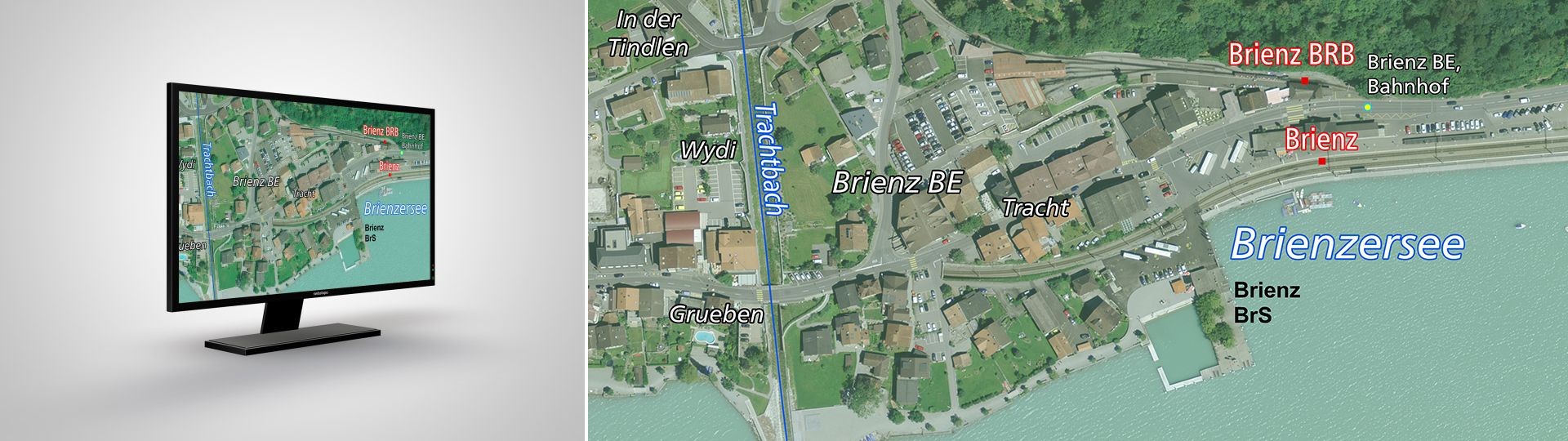
Applications

In combination with other geodata products, swissNAMES3D is a particularly useful labelling dataset which provides the ideal basis for developing name databases and search engines.

Application examples:

  • Adding geographic names to various geodata sets
  • Flexible and clear presentation of names on aerial photographs, maps and plans
  • Labelling to aid comprehension of 3D visualisations (e.g. panoramic views)
  • Developing databases of names for online solutions and search engines
  • Creating directories of geographic names

Terms of use

Additional information

Technical details

Structure

The swissNAMES3D vector data set is a compilation of names from the topographic landscape model (TLM). The names belong to TLM landscape features and are linked to their 3D geometries, which means that they are also georeferenced. The basic data model comprises three thematic layers, which differ according to their geometry type (point, line, polygon). Thanks to additional attributes, the names can be categorised within a layer according to TLM feature classes. 

Type of geometry

Data content

Lines 

• Names of transport infrastructure (bridges, tunnels, cable cars, etc.)
• Names of sports facilities
• Names of watercourses

Points 

• Topographic names (peaks, passes, etc.)
• Names of single point objects
• Field and local names
• Public transport stops
• Building names 

Polygons

• Housing development names
• Lake names
• Names of landscapes and regions
• Terrain names (glaciers, valleys, etc.)
• Names of sites (transport facilities, schools, recreation facilities, etc.)

Perimeter

swissNAMES3D contains geographic names from Switzerland and the Principality of Liechtenstein.

File formats

swissNAMES3D is available to download free of charge as a data packet in the following output formats:

  • ESRI File Geodatabase
  • ESRI Shapefile
  • CSV text file

Coordinate systems

The data sets are available in the following Swiss coordinate systems:

  • LV03 LN02
  • LV95 LN02

Updating

The six-year updating cycle of swissNAMES3D is closely linked to that of the topographic landscape model. One edition of this data set is published each year.

Quality

swissNAMES3D has the following distinctive high-quality features:

  • Full national coverage in homogeneous form and quality
  • Horizontal and vertical accuracy: 0.2 to 1.5m in all three dimensions for well-defined landscape features, such as roads; 1 to 3m in all three dimensions for features without clear boundaries, such as housing developments
  • Lines and polygons correspond to the areas to which names apply (e.g. housing development)
  • Basic data model
  • Promotes multilingualism 

Documents

Almost all publications concerning swissNAMES3D are only available in German and French. Please select your preferred language in the navigation bar to view the desired document.

swissNAMES3D - Access to geodata


Federal Office of Topography swisstopo Seftigenstrasse 264
P.O. Box
3084 Wabern
Tel.
+41 58 469 01 11

E-mail

Federal Office of Topography swisstopo

Seftigenstrasse 264
P.O. Box
3084 Wabern

Show map