
swissJURA3D
swissJURA3D is the 3D geological model of the Swiss Jura.
The 3D geological model swissJURA3D is a three dimensional representation of the subsurface of the Swiss Jura, from northwest of the Molasse Basin to the national border. It covers the Swiss part of the Jura (Internal and External Folded Jura) as well as the Swiss parts of the Haute-Saône Platform, the Upper Rhine Graben and the South German Platform. The modelling is carried out as part of the programm NGM – National Geological Model.
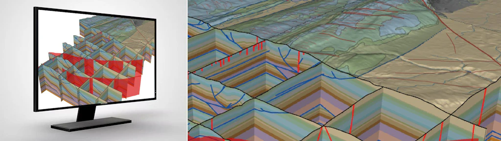
The swissJURA3D model output consists of three central components: a dense network of geological cross-sections (fence diagram), fault surfaces, and the lithostratigraphic reference horizon surface “Top Ifenthal Formation”.These components are interlinked and together form a coherent representation of the geological structures.
The primary data source is the geometrically harmonised surface mapping vector data from swissGEOCOVER2D. This is supplemented with geological cross-sections, borehole and geophysical data, resulting in a coherent 3D geological model based on a consistent geological and kinematic interpretation.
The first model area, St-Cergue – Le Sentier, can be viewed, queried and downloaded at viewer.swissgeol.ch. The model description, containing further information on the methodology and workflow, is also available via the viewer.
Further model areas are currently underway and will be sequentially modelled and published by 2030.
Applications
3D geological models such as swissJURA3D allow a spatially consistent representation of complex geological structures, thereby providing a valuable basis for various applications.
These include the planning and implementation of infrastructure projects, the sustainable use of the subsurface, the assessment of groundwater and mineral resources, and the analysis of geological issues. The three-dimensional perspective facilitates the identification of subsurface features and their relationships and enables more informed decisions to be made.