
National survey control network: re-measurement campaigns
Every six years, swisstopo re-measures the national survey control network. Thanks to these measurements it is possible to obtain more precise information regarding Switzerland’s tectonic stability. Almost all geodata (i.e. data with a spatial context) that are used in Switzerland are based on one of the national survey control (fixed point) networks. It is therefore all the more important to periodically re-measure these networks. State-of-the-art satellite measurement technology is used for this purpose.
Since 1998, swisstopo has measured the control network of the 1995 national survey (LV95) every six years in the framework of a measurement campaign lasting several weeks. The objective here is to determine whether the coordinates of the LV95 fixed points are correct, or whether the points may have shifted since the last measurement (and if so, by how much). The coordinates of all these points are measured using global satellite navigation systems (GNSS). The evaluation of the measurements provides the basis for the national spatial reference and makes it possible to obtain valuable information about Switzerland’s tectonic stability.
In 2022 the fifth measurement campaign (GNSS2022) is to be carried out since the initial creation of the network.
What is a control network?
The term “control network” refers to fixed points, the coordinates of which are known and which are permanently marked with a stone or bolt – in some cases located in a shaft.
These points form the basis for all geodata, i.e. all data with a spatial reference. They can also be used for reliably and accurately calculating other data, for example for the cadastral survey.
There are two types of fixed points: position control points and height control points. These are classified in categories 1 to 3. The national survey, which is carried out by swisstopo, is responsible for category 1 (position control and height control) fixed points, which form the basis for all surveying activities carried out in Switzerland. In their turn, the cantons and municipalities are responsible for category 2 and 3 fixed points.
With the 1995 national survey (LV95), the previous fixed points that were based on triangulation were replaced. 220 new fixed points (LV95 points) were added to the control network.
Results of the measurement campaign
The measurement data recorded by the Swiss national survey are combined with the data measured by our neighbouring countries. In this way it is possible obtain information about the stability of the control network and determine where, and to what extent, tectonic shifts (for example, mountain uplift) may have occurred in Switzerland.
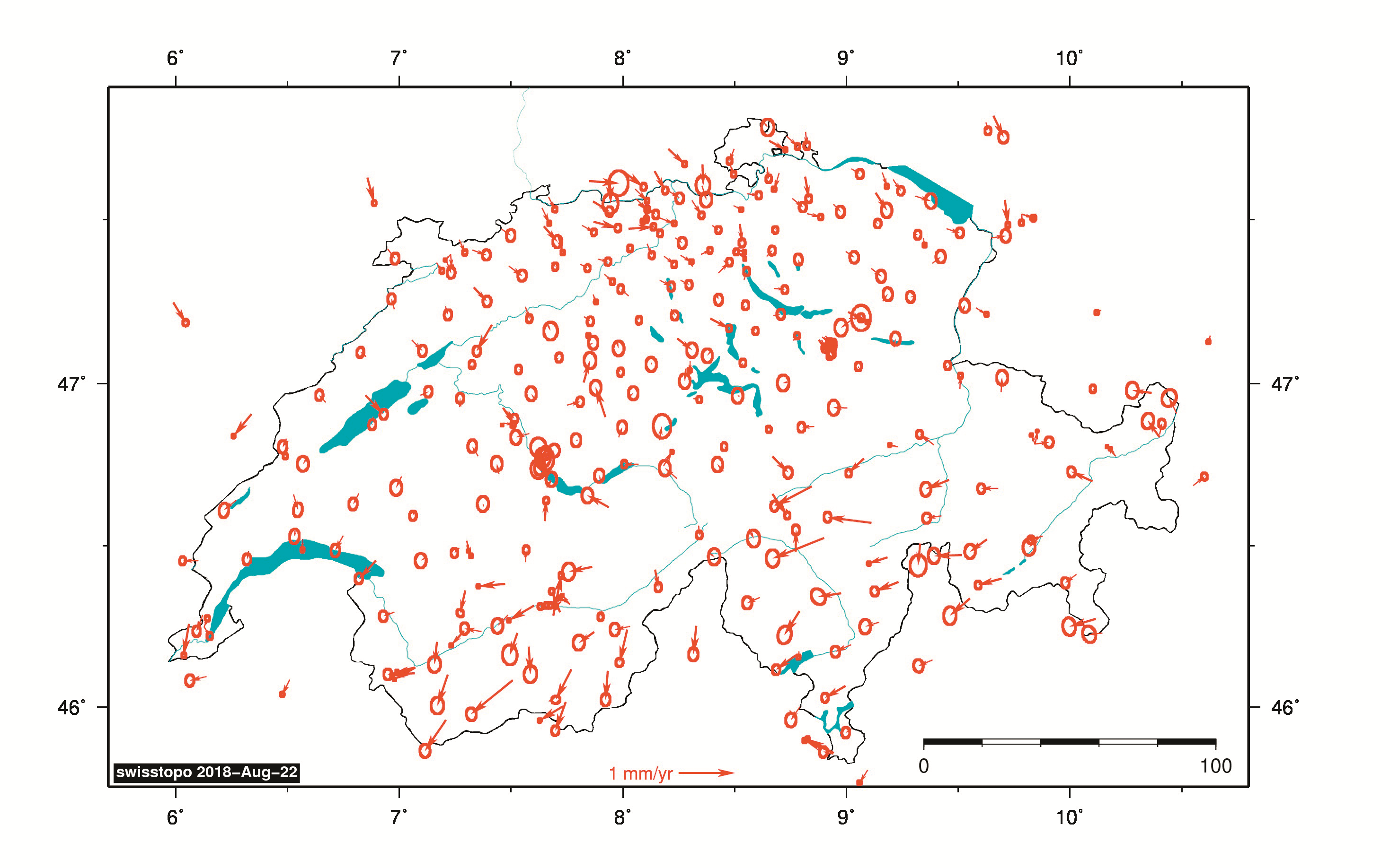
Figure 1 depicts the evaluation of the 2016 measurement campaign: during the past 30 years, most of the approximately 220 LV95 points have shifted by less than 2 centimetres. The evaluation shows that position control points shift by up to 1 millimetre per annum in some regions. In addition, mountain uplift of approximately 1 to 3 millimetres per annum was also recorded.
With the LV95 control points and periodical measurement of all 220 points the basis is created for a precise, reliable and efficient national survey, which is used for the production of all maps and the creation of geodata.
The video tutorials explain the Swiss coordinates system, and the global coordinates system with geographic longitudes and latitudes, in detail.
Links
Federal Office of Topography swisstopo
Seftigenstrasse 264
3084 Wabern