
Providing the means to Act Against Drought
Periods of drought are becoming more intense and more frequent in Switzerland. They deplete water resources, weaken ecosystems, increase the risk of forest fires, threaten agriculture, and hinder navigation. To counter these growing risks, the Federal Council has mandated the creation and operation of a national monitoring and alert platform that combines meteorological, hydrological, and satellite data.
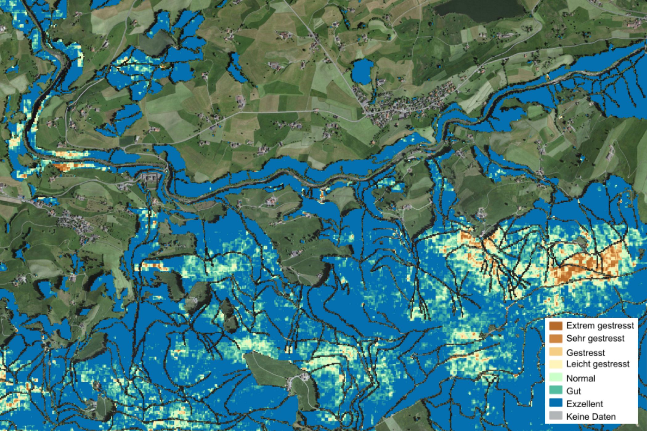
In this interdisciplinary approach, swisstopo uses satellite imagery and advanced geodata processing techniques to monitor the effects of environmental stress, particularly drought, on nature at a national scale. The analysis of current satellite data allows swisstopo and MeteoSwiss to measure vegetation density and vitality as well as surface temperature. This data, updated daily, is compared with that of the reference climate period 1991 – 2020. In this way, swisstopo determines the vegetation health index. This operational tool enables the relevant authorities to intervene quickly and in a targeted manner to protect water resources, agriculture, forests, and navigation.
This new drought platform fills a gap in natural hazard warnings and, therefore, in civil protection.
Additional content
Drought
As part of the «Drougth Project», the Federal Office of Topography swisstopo, the Federal Office of Meteorology and Climatology MeteoSwiss and the Federal Office for the Environment FOEN are jointly developing a national early warning system for drought. Swisstopo supports these efforts by providing pre-processed satellite images and vegetation indices that can be analysed.
swissEO Product Line: Near-Realtime Satellite Data for Drought Monitoring – and Other Applications
The increasing frequency and intensity of drought periods, such as those in 2018 and 2022, pose a growing challenge. Comprehensive drought monitoring is essential to enable timely responses. On behalf of the Federal Council, corresponding geodata products are being developed to provide precise, near-real-time data.
National drought platform
The monitoring and warning system was created to inform authorities, sectors and the public about drought risks at an early stage so that appropriate preparations can be made. This drought platform has been set up as part of this system. It provides comprehensive information on the current drought situation as well as on past events and forecasts going forward. Warnings are also issued when necessary.
Folio 2025 – For a safe Switzerland
Security extends far beyond the military sphere. It encompasses issues such as the prevention of natural hazards, the sustainable management and supply of resources, the protection of property rights, the stability of infrastructure and the provision of information to the public. Geodata plays a key role in all these areas.


