
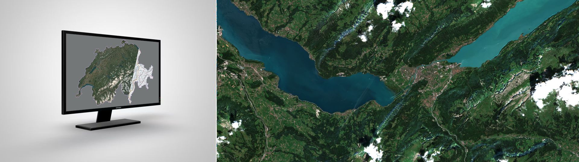
swissEO S2-SR
Optical satellite data (Sentinel-2) used to show the reflectances of the land surface for the four channels Red, Green, Blue and near Infrared in a spatial resolution of 10 metres. Further channels are available with a spatial resolution of twenty metres.
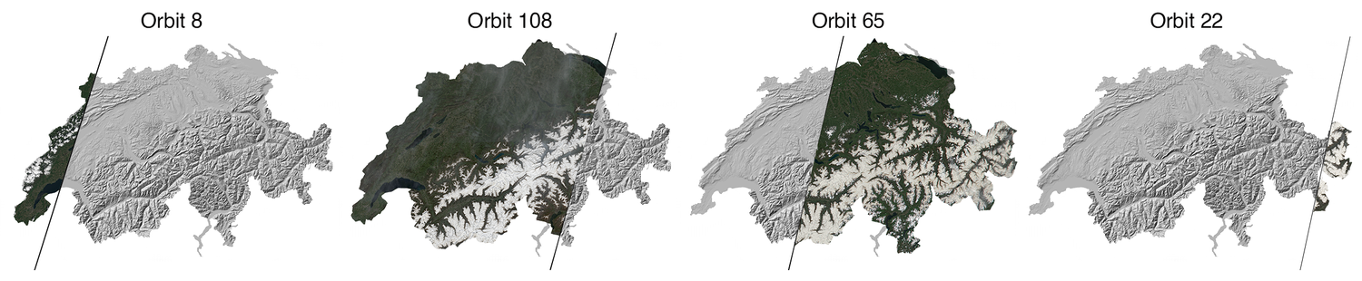
Switzerland is mapped by four orbits of the satellite overflight (see graphic below). The overlapping orbits result in a complete image of Switzerland approximately every three to five days, but the usefulness of the data is heavily dependent on meteorological conditions at the moment of overflight, as the imaging sensor cannot see through clouds. In addition to the already applied localisation of the data, a co-registration of the data optimised for Switzerland is applied for a sub-pixel positional accuracy and and a reprojection is carried out in a uniform coordinate system. Also included are optimised quality layers with masks for clouds (and cloud shadows) and topographic shadows.
Data visualisation and availability
The most recent dataset can be displayed as a true color image in the BGDI map viewer at https://map.geo.admin.ch/?layers=ch.swisstopo.swisseo_s2-sr_v100. In the BGDI WMS, this dataset can be displayed using the «ch.swisstopo.swisseo_s2-sr_v100» layer.
It currently takes around three days to process a newly recorded data set after it has been recorded. To find out which data acquisitions are planned for the current and following week, please visit the website of the European Space Agency (ESA) to check the recording schedules of the Sentinel-2 satellites.
In order to view a time series, there is a catalogue or a machine-readable list of the recorded and processed data sets, as well as a further list with the days on which no data was recorded or the cloud cover was greater than 80% and the data was therefore not processed. To display older data sets as TrueColor RGB images in the BGDI map viewer, a URL parameterisation must be carried out. The in the following link is replaced by the timestamp of the data acquisition in the format “yyyy-mm-ddtHHMMSS” (for example: 2025-01-01t235959).
For example for the 2024-05-10t102021 dataset:
Additional information
Download raw data
Raw data can be downloaded via the collection «ch.swisstopo.swisseo_s2-sr_v100» in the STAC interface of the BGDI:
- Download interface: swissEO S2-SR: Optical satellite data (Sentinel-2) (admin.ch)
- Download API documentation: REST Interface: Spatial Temporal Asset Catalog API (admin.ch)
- Google Earth Engine: S2-SR Image Collection [projects/satromo-prod/assets/col/S2_SR_HARMONIZED_SWISS]
- Accessing STAC via Python - Introduction (Jupyter Notebook)
- Image processing via Python using STAC (Jupyter Notebook)
- Streaming of swissEO products in QGIS
Terms of use
swissEO may be used, distributed and made accessible. Furthermore,it may be enriched and processed and also used commercially. A reference to the source is mandatory. In the case of digital or analogue representations and publications, as well as in the case of dissemination, the following source references must be attached in any case:
© swisstopo, Contains modified Copernicus Sentinel data [Year]
Further information on the terms of use can be found on the terms of use webpage.
Index
Federal Office of Topography swisstopo
Seftigenstrasse 264
3084 Wabern