
CLASSIFY - Border points
Automatic detection and classification of the nature of border points on old cadastral plans. Beneficiary administration: Canton Fribourg.
Context
In Fribourg municipalities where official surveying to the MO93 standard is not yet in force in the land register, boundary points are not always shown in the official surveying data set. This generates numerous errors in the CheckCH and makes it more difficult for users to understand, even though these border points can be identified on the old plans.
The location of border points is known thanks to the manual digitization of lines carried out a few years ago. However, classifying them based on old plans is a very time-consuming task. Furthermore, the location of border points sometimes remains approximate due to the existence of different versions of the same area and to the difficulties of georeferencing such old material. Given these challenges, the Canton of Fribourg turned to the STDL to develop an algorithm for classifying the nature of boundary points on cadastral plans.
Method
Two methods were tested for this project:
Image classification using machine learning
The position of the points is approximately known. An image around the presumed position of each point is created and classified.
The classification algorithms tested yielded fairly satisfactory metrics, with recall rates of up to 0.73. However, the quality did not hold up when the method was extended to larger areas.
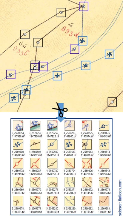
Instance segmentation using the STDL object detector
The use of a deep learning method applied to plans allows for better consideration of the context surrounding each point, and the result is less affected by their approximate location. The algorithm used is the STDL object detector.
A final F1 score of 0.85 was achieved for classified border points thanks to detections produced by instance segmentation. Experts reviewed the results and deemed them satisfactory.

Results
Ultimately, instance segmentation using the STDL object detector was chosen and applied to 602 cadastral maps in Fribourg in order to classify 50,000 points from the official survey.
Documented resources
All STDL work is published under an open license, and we encourage you to use it in your projects.
Index
Back to the homepage of STDL
Swiss Territorial Data Lab
The Swiss Territorial Data Lab (STDL), launched in 2020 as part of the Swiss Strategy for Geoinformation (SGS), was part of Action Area 5, “Promoting innovation.” This lab offered public administrations a real testing ground where they could try out new approaches to meet their specific challenges. The STDL promoted collaboration between technical and business experts in order to co-create effective and tailored solutions.
Office fédéral de topographie swisstopo
Seftigenstrasse 264
3084 Wabern