Swiss Territorial Data Lab
The Swiss Territorial Data Lab (STDL), launched in 2020 as part of the Swiss Strategy for Geoinformation (SGS), was part of Action Area 5, “Promoting innovation.” This lab offered public administrations a real testing ground where they could try out new approaches to meet their specific challenges. The STDL promoted collaboration between technical and business experts in order to co-create effective and tailored solutions.
The video is also available in German HERE.
Goal
The Swiss Territorial Data Lab aimed to solve concrete problems faced by public administrations by applying data science to geodata.
How it works
Thanks to funding from the Swiss Strategy for Geoinformation, the STDL built up a team of two data scientists, who were joined each year by a university intern. The team was also supported by resources from public administrations, which devoted time to the projects.
A steering committee made strategic decisions and approved incoming projects. It was composed of representatives from cities, cantons, federal offices, as well as the SGS and the KGK.
STDL projects were not limited to the territories of committee members. Any public administration could request assistance from the STDL.
Approach
Exploratory projects were carried out in a co-creation mode between domain experts from public administrations and technical experts from the STDL. These projects varied in duration, generally between 6 and 8 months.
Deliverables
- Prototypes to assess the technical feasibility of projects
- The availability of the source code and detailed documentation for each project
- Transfer of knowledge on methodologies and processes developed during exploratory projects
Activity report
After five successful years, the STDL project has come to an end. Discover the projects completed and the key achievements since its launch in 2020. The journal is only available in German or in French.
Swiss Territorial Data Lab – Raum für kollektive Innovation
Swiss Territorial Data Lab – Espace d’innovation collective
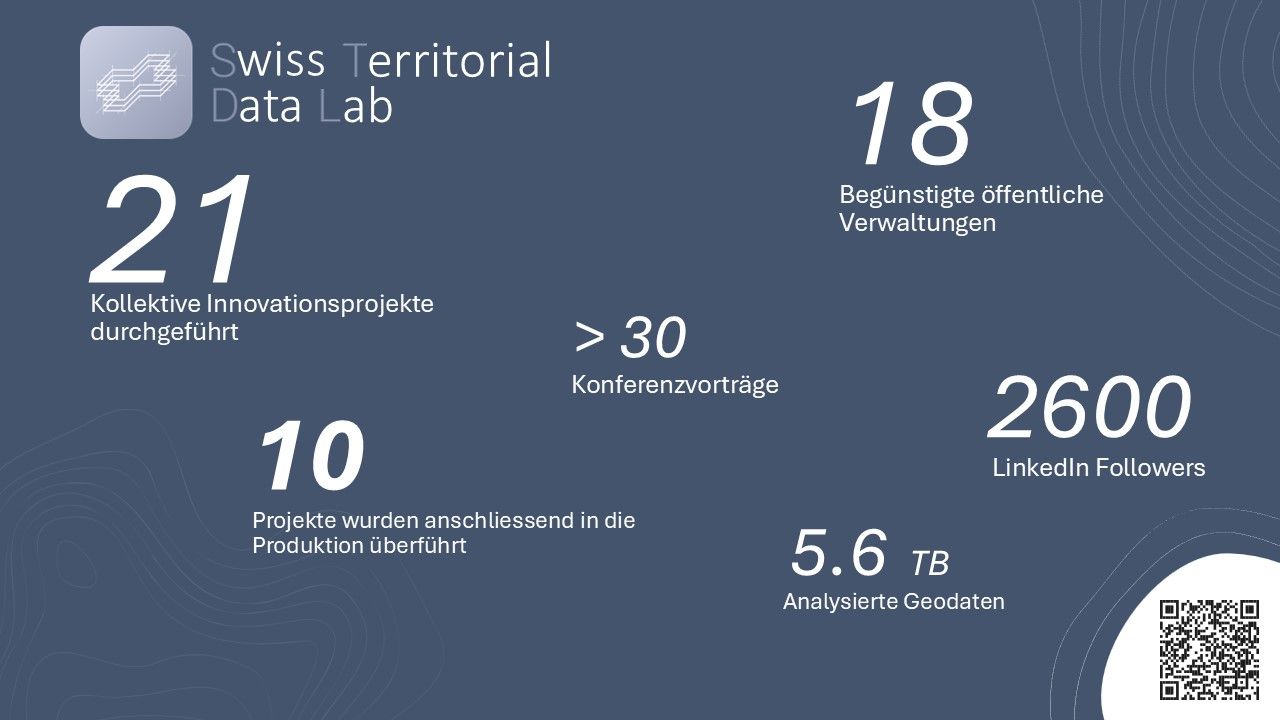
Key numbers
Contact
Federal Office of Topography swisstopo
Exploratory projects
Some project pages are only available in German and French. English content will be available soon.
Index
FIND - Sinkholes
Mapping of sinkholes in Switzerland using automatic methods. Beneficiary administration: swisstopo.
FIND - Anthropogenic soils
Automatic identification of degraded soils caused by human activity and suitable for restoration. Beneficiary administrations: Canton of Ticino and Canton of Vaud.
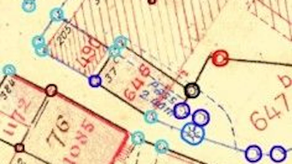
CLASSIFY - Border points
Automatic detection and classification of the nature of border points on old cadastral plans. Beneficiary administration: Canton Fribourg.
CLASSIFY - Vegetated rooftops
Automatic detection of green roofs and vegetation type. Beneficiary administrations: Canton Zürich and Canton Geneva.
SEGMENT - Soil and non-soil
Automatic soil segmentation based on aerial images. Beneficiary administrations: Canton of Fribourg, Canton of Vaud and Canton of Basel-Stadt.
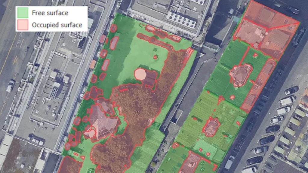
CLASSIFY - Free spaces on rooftops
Detection of objects present on roofs and identification of free spaces. Beneficiary administration: Canton of Geneva.
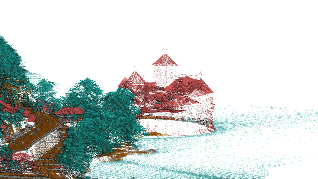
MONITOR - Classification of a LiDAR dataset
Only available in German and French - Semi-automatic quality control of the classification of a LiDAR dataset. Beneficiary administrations: swisstopo, Canton of Neuchâtel and Canton of Geneva.
SEGMENT - Old cadastral maps
Only available in German and French - Automatic extraction and vectorization of objects on original Dufour maps. Beneficiary administrations: Canton of Geneva and swisstopo.
MONITOR - Areal statistics
Only available in German and French - Partial automation of areal statistics for land using information from spatial and temporal neighbors. Beneficiary administration: Federal Statistical Office.
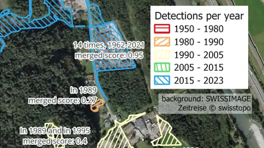
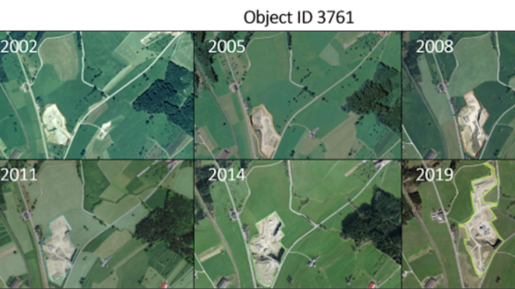
MONITOR - Mineral extraction sites
Only available in German and French - Identification and monitoring of the development of mineral extraction sites in Switzerland. Beneficiary administration: swisstopo.
CLASSIFY - Type of road surface
Only available in German and French - Automation of the interpretation process of aerial images to determine the type of road surface. Beneficiary administrations: swisstopo and the canton of Neuchâtel.
CLASSIFY - Health status of beech trees
Only available in German and French - Methodology for assessing the health status of beech trees using aerial photographs and LiDAR point clouds. Beneficiary administration: Canton of Jura.
MONITOR - Construction period of buildings
Only available in German and French - Automatic detection of the construction period of buildings based on national maps. Beneficiary administrations: Federal Statistical Office, Canton of Valais, Canton of Neuchâtel, Canton of Fribourg, Canton of Vaud, and the Principality of Liechtenstein.
FIND - Single trees in urban areas
Only available in German and French - Automated inventory of single trees using LIDAR data and hyperspectral images for forestry. Beneficiary administrations: Canton of Geneva and Canton of Neuchâtel.
FIND - Thermal panels
Only available in German and French - Automatic detection of thermal panels for cantonal energy agencies based on aerial images. Beneficiary administrations: Canton of Geneva, Canton of Neuchâtel, and Canton of Vaud.
COLLABORATE - Co-production of official survey data
Only available in German and French - Working together on specific official survey data. Beneficiary administration: Canton of Thurgau.
FIND - Silage bales
Only available in German and French - Update of information on “utilised agricultural areas” for cantonal agricultural services. Beneficiary administration: Canton of Thurgau.
MONITOR - Canopy growth
Only available in German and French - Development of a tree growth model to assess the influence of canopy cover on heat islands. Beneficiary administrations: Canton of Geneva.
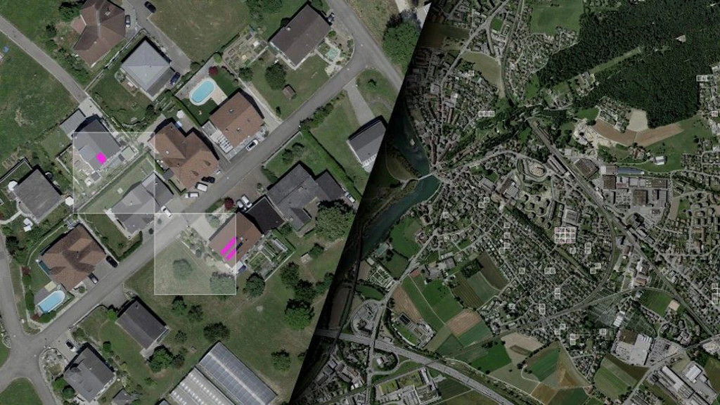
FIND - Swimming pools
Only available in German and French - Automatic detection of swimming pools using aerial images for cantonal geoinformation agencies. Beneficiary administrations: Canton of Geneva.