
CLASSIFY - Free spaces on rooftops
Detection of objects present on roofs and identification of free spaces. Beneficiary administration: Canton of Geneva.
Context
The current climate crisis is pushing governments to rethink their development policies, which will change the face of our cities and towns. To meet the challenges of the energy and ecological transitions, the use of roofs is a major asset in offsetting land use and optimizing building use. For example, the installation of green roofs helps reduce heat islands and preserve biodiversity in cities. In addition, roofs are also a key space for local solar production with a low impact on our landscapes. Knowledge of the actual occupancy of roofs is therefore a strategic issue for prioritizing development. However, at present, the inventory of free roof space and the number of existing solar and green installations, which are necessary to assess installation potential, are not very accurate.
Method
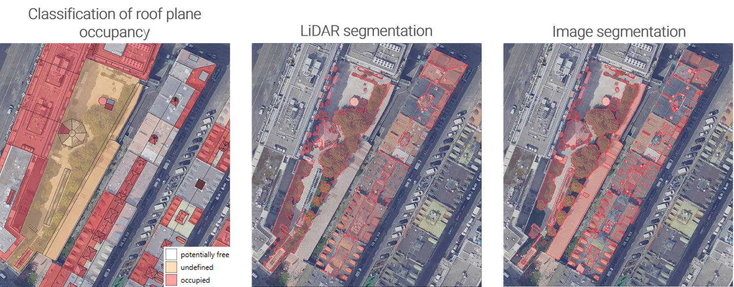
The aim of this project, in collaboration with the canton of Geneva, is to detect objects and identify free space on roofs. The end products are vector layers. Three methods were tested to determine the presence of obstacles:
- Classification of roof sections according to their occupancy: a statistical analysis of the intensity and roughness of LiDAR point clouds allows roof sections to be classified using a random forest algorithm into the categories “occupied,” “potentially free,” and “undefined.”
- LiDAR data segmentation: this method aims to identify obstacles that extend beyond roof sections. The RANSAC and DBSCAN algorithms from the Open3D Python library are used to separate points in the cloud belonging to roof sections and potential objects.
- Image segmentation: this method, based on a deep learning model, is used to identify potential objects on roofs in images. It relies on the Segment Anything Model (SAM) and segment-geospatial tools.
The data used are LiDAR point clouds and orthophotos acquired by the State of Geneva in 2019, as well as the roof slope layer published by the SITG in 2023. For 122 buildings, a ground truth of the objects present on the roofs has been established.
Results
The object detection capability of segmentation methods is satisfactory, with an F1-score between 0.75 and 0.76, but the median IoU, between 0.37 and 0.40, remains relatively low and could be improved. LiDAR segmentation produces detections whose shapes are unsatisfactory according to domain experts and is unable to identify low-height objects (i.e., those very close to the ground).
Image segmentation was deemed satisfactory by experts, but it produces false detections due to color variations and requires significant computing resources for large-scale implementation.
Finally, the method for classifying roof occupancy is reliable, achieving an overall accuracy of ~0.84. It also has the advantage of being inexpensive in terms of IT resources. This method has been selected for use across the canton of Geneva to provide an indication of the potential roof space available for the development of new infrastructure.
Documented resources
All STDL work is published under an open license, and we encourage you to use it in your projects.
Index
Back to the homepage of STDL
Swiss Territorial Data Lab
The Swiss Territorial Data Lab (STDL), launched in 2020 as part of the Swiss Strategy for Geoinformation (SGS), was part of Action Area 5, “Promoting innovation.” This lab offered public administrations a real testing ground where they could try out new approaches to meet their specific challenges. The STDL promoted collaboration between technical and business experts in order to co-create effective and tailored solutions.
Office fédéral de topographie swisstopo
Seftigenstrasse 264
3084 Wabern