
CLASSIFY - Vegetated rooftops
Automatic detection of green roofs and vegetation type. Beneficiary administrations: Canton Zürich and Canton Geneva.
Context
With global warming, urban centers are increasingly suffering from heat island effects. Vegetation is recognized as a component of the urban environment that helps to cool it down. Thus, the study of green roofs contributes to understanding the green capacity of a city and to planning future urban development measures. To accurately identify and quantify green roofs on a large scale, a (semi-)automatic processing method must be developed.
In collaboration with domain experts from AWEL (Amt für Abfall, Wasser, Energie und Luft - Luft, Klima und Strahlung) in the Canton of Zurich and OCAN (Office cantonal de l'agriculture et de la nature) in the Canton of Geneva, two steps of the solution were identified: detecting green roofs and determining the type of vegetation.
Work in this direction has already been carried out in these cantons. A study conducted by the City of Zurich between 2013 and 2015 examined more than 140 roofs and their vegetation. In Geneva, the roof cover layer has been in place since 2009 and was recently updated (in 2019 and 2021). However, these processes are not yet automated and/or exhaustive. The cantons have therefore called on the Swiss Territorial Data Lab to work together to find an innovative methodology.
Method
In this project, STDL used data science to derive information about green roofs and vegetation types from aerial images. From traditional image analysis techniques to recent deep learning methods, different strategies have been considered based on the latest state-of-the-art results.
However, no (semi-)automated prediction can be verified without a control data set, known as the ground truth. Existing data must first be listed, prepared, and, if necessary, supplemented with additional examples. Domain experts from the cantons of Zurich and Geneva checked and classified more than 4,000 roofs by assessing the situation on the basis of aerial images.
In the first phase of the project, the STDL trained a random forest and logistic regression model to classify roofs as “bare” or “vegetated” based on aerial images.
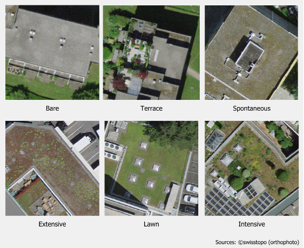
The second step involved classifying the type of vegetation. To perform this task, a deep learning algorithm was developed. The algorithm is an adaptation of the DeepLabV3 model, reusing its ASPP (Atrous Spatial Pyramid Pooling) module and processing the output signal to perform image classification. The model was trained for the different vegetation classes.
Results
In the first step, the combination of random forest and logistic regression methods achieved a recall score of 0.84 for the vegetated class and an F1-score of 0.86 for both classes.
In the second phase, the deep learning algorithm recorded the following recall values: 0.91 for the detection of roofs without vegetation, 0.77 for roofs used as terraces, 0.91 for grass-covered roofs, and 0.63 / 0.78 / 0.55 for roofs covered with spontaneous / extensive / intensive vegetation, respectively.
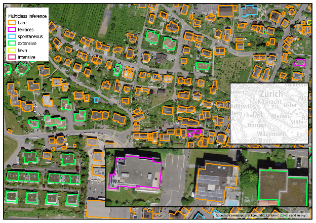
The project was successfully implemented across both cantons and the corresponding GIS layers were delivered.
Documented resources
All STDL work is published under an open license, and we encourage you to use it in your projects.
Index
Back to the homepage of STDL
Swiss Territorial Data Lab
The Swiss Territorial Data Lab (STDL), launched in 2020 as part of the Swiss Strategy for Geoinformation (SGS), was part of Action Area 5, “Promoting innovation.” This lab offered public administrations a real testing ground where they could try out new approaches to meet their specific challenges. The STDL promoted collaboration between technical and business experts in order to co-create effective and tailored solutions.
Office fédéral de topographie swisstopo
Seftigenstrasse 264
3084 Wabern