
FIND - Anthropogenic soils
Automatic identification of degraded soils caused by human activity and suitable for restoration. Beneficiary administrations: Canton of Ticino and Canton of Vaud.
Context
In order to guarantee the Swiss population a minimum food supply in the event of a crisis, federal legislation on land use planning provides for the establishment and protection of crop rotation areas (CRA). CRA are productive agricultural lands whose quality must be protected, and a minimum area per canton must be maintained. However, construction projects may sometimes require the use of CRA. In such cases, the losses must be offset by creating new CRA of equivalent size. In order to determine the priority areas to be converted into CRA, the cantons are required to provide a register or indicative map of potentially reclaimable and cultivable land. Priority may be given to land that has been degraded by human activity in the past, for example. These areas generally correspond to polluted land, landfills, etc.
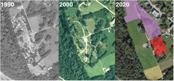
For this project, the STDL was asked by the cantons of Ticino and Vaud to develop a method for automatically detecting land use over time. In particular, sites that have been used for human activities were to be identified. These areas can then be prioritized for rehabilitation.
Method
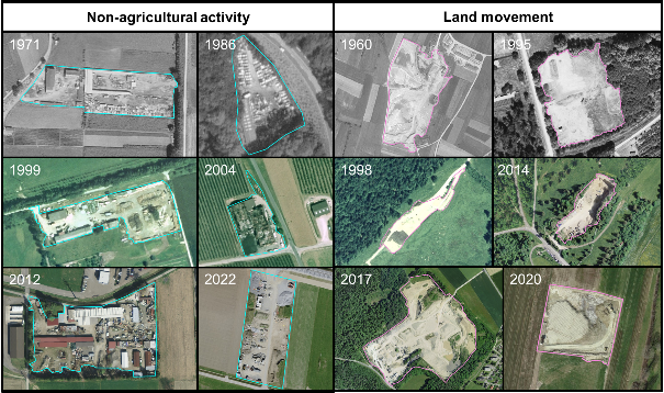
A ground truth was created by experts for the “non-agricultural activity” and “land movement” classes. It included a selection of objects between 1950 and 2023 and was used to train the STDL object detector to segment the two classes of interest over the years. Tests were conducted to standardize the colors of RGB and black-and-white images, but ultimately, working with the original images yielded the best results.
.png?auto=format)
Results
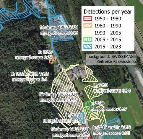
The best STDL object detector model has a recall of 38% and a precision of 60% on the test dataset. The results are therefore poor due to numerous missed objects and confusion between the two classes. By combining several models and post-processing, the recall was improved to 58%, making the results more acceptable.
Once inference had been performed for all years and the two classes merged into a single “anthropogenic activities” class, 92% of the label area is recovered and 30% of the detection area covered a label. The accumulation of detections over the years therefore improved the completeness of the result, but reduced its precision. A complete check of the detections is therefore recommended.
The Canton of Ticino provided the vector layers enabling the identification of multiple land uses and thus restricting the results to areas suitable for CRA. The Canton of Vaud preferred to keep the results as they were in order to identify all potential anthropogenic activities.
Documented resources
All STDL work is published under an open license, and we encourage you to use it in your projects.
Index
Back to the homepage of STDL
Swiss Territorial Data Lab
The Swiss Territorial Data Lab (STDL), launched in 2020 as part of the Swiss Strategy for Geoinformation (SGS), was part of Action Area 5, “Promoting innovation.” This lab offered public administrations a real testing ground where they could try out new approaches to meet their specific challenges. The STDL promoted collaboration between technical and business experts in order to co-create effective and tailored solutions.
Office fédéral de topographie swisstopo
Seftigenstrasse 264
3084 Wabern