
SEGMENT - Soil and non-soil
Automatic soil segmentation based on aerial images. Beneficiary administrations: Canton of Fribourg, Canton of Vaud and Canton of Basel-Stadt.
Context
Contaminated soil poses various health risks. In particular, contamination with lead, mercury and polycyclic aromatic hydrocarbons (PAHs) is currently a focus of the Federal Office for the Environment. For the prevention and management of soil movement during construction work, it is therefore necessary to know the exact location of potentially contaminated soil.
Current maps, which indicate soil type, are often limited to the level of detail provided for individual land parcels and are therefore inaccurate in the vicinity of houses (a land parcel often includes a house and a garden), even though this is a critical area.
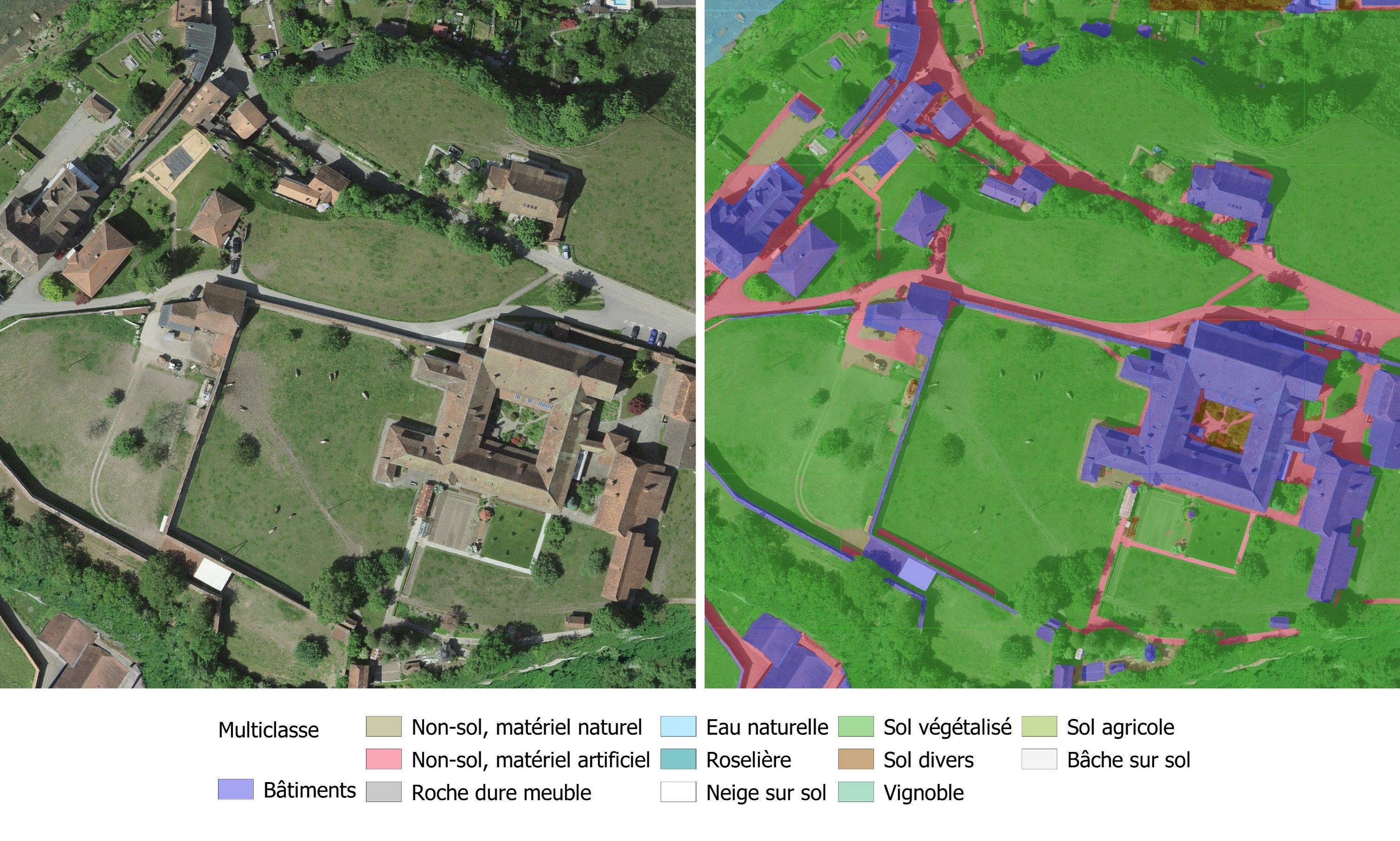
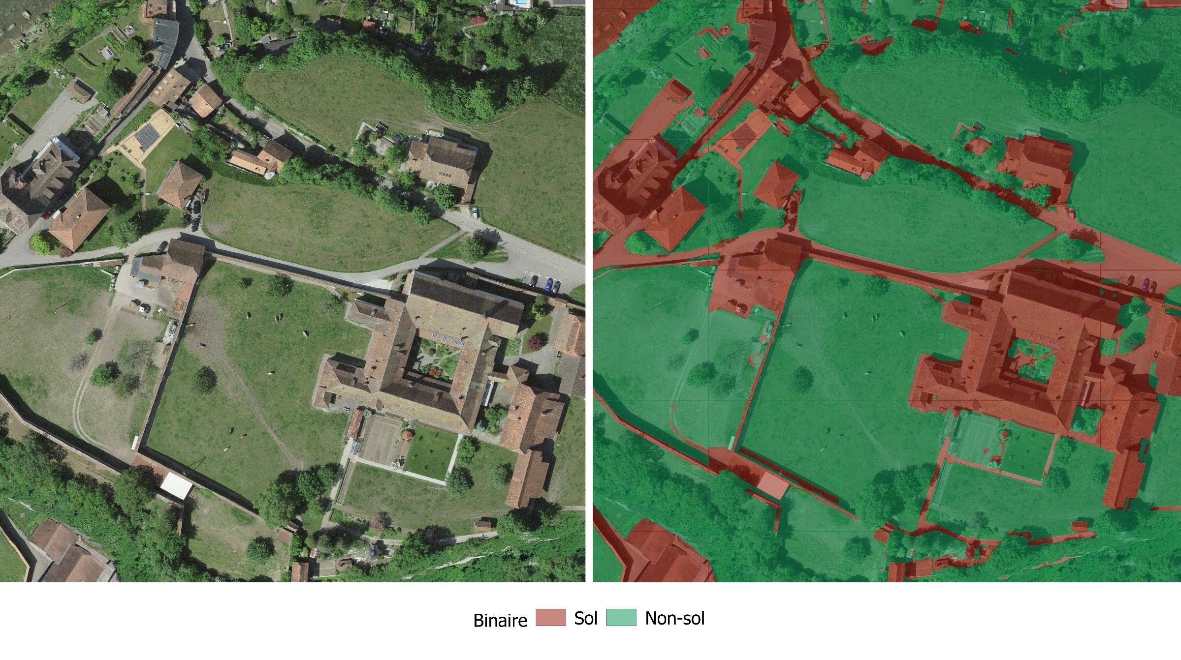
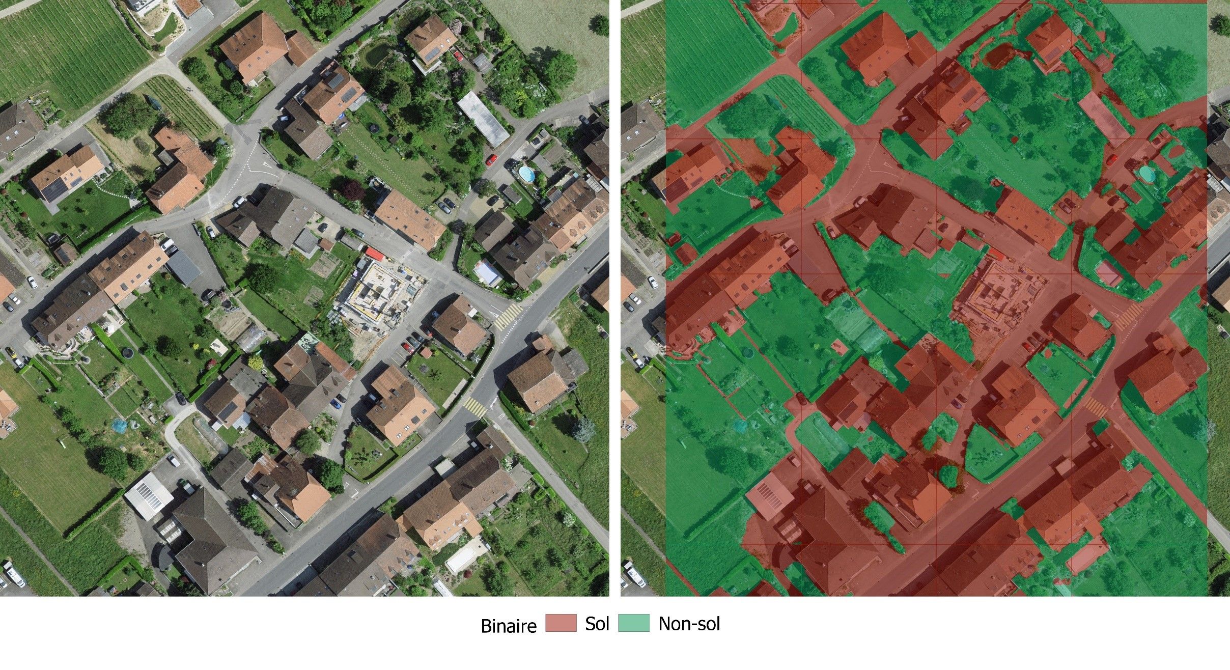
This project aims to create a high-resolution map showing potentially polluted soils, i.e., unsealed soils such as fields, lawns, or clay soils. The target spatial resolution is 1 m. Soil classification is based on an automatic image segmentation method applied to multichannel aerial images (R, G, B).
The purpose of creating this map is to:
- reduce the time spent by public services manually identifying open ground areas from orthophotos;
- improve cantonal inventories of potentially contaminated sites;
- develop and test a methodology that can be used by other administrations.
The project was carried out in collaboration with the Canton of Fribourg.
Method
The first step was to establish a ground truth consisting of images manually segmented by soil experts for representative classes of the Fribourg region.
This enabled a quantitative evaluation of deep learning models dedicated to land cover prediction tasks currently being developed by the National Institute of Geographic and Forest Information (IGN), the Haute Ecole d'Ingénierie et de Gestion du Canton de Vaud (HEIG-VD), and the Federal Statistical Office (FSO).
Subsequently, the model developed by HEIG-VD, which showed particularly promising results in urban areas, was trained with part of the ground truth data; the rest was kept for evaluating the results. This step made it possible to optimize the model's performance for the present use case and the project-specific data: higher-resolution imagery, different vegetation appearances due to seasonal differences, and a customized classification scheme.
Results
With the optimized model, soil classes can be inferred on any Swiss image tile, as in the examples below.

Following the satisfactory results of the algorithm after optimization with ground truth data from Fribourg, the beneficiaries were interested in enriching it with additional examples in order to further improve the model's performance.
In addition, the Canton of Vaud has joined the project, as it is interested in exploring the possibility of soil monitoring between two successive acquisitions of SWISSIMAGE 10 cm. This application will present new challenges, notably that of differentiating between the real changes from those due to model prediction errors.
To do this, the model must first be trained using real-world data from the Canton of Vaud based on SWISSIMAGE 10 cm images taken in summer. Then, in post-processing, information such as the model's confidence score, types of class changes, and geometric criteria will be used to obtain a product that provides information on actual land cover changes.
Documented resources
All STDL work is published under an open license, and we encourage you to use it in your projects.
Index
Back to the homepage of STDL
Swiss Territorial Data Lab
The Swiss Territorial Data Lab (STDL), launched in 2020 as part of the Swiss Strategy for Geoinformation (SGS), was part of Action Area 5, “Promoting innovation.” This lab offered public administrations a real testing ground where they could try out new approaches to meet their specific challenges. The STDL promoted collaboration between technical and business experts in order to co-create effective and tailored solutions.
Office fédéral de topographie swisstopo
Seftigenstrasse 264
3084 Wabern