
Make the most of your bike tour with the national map
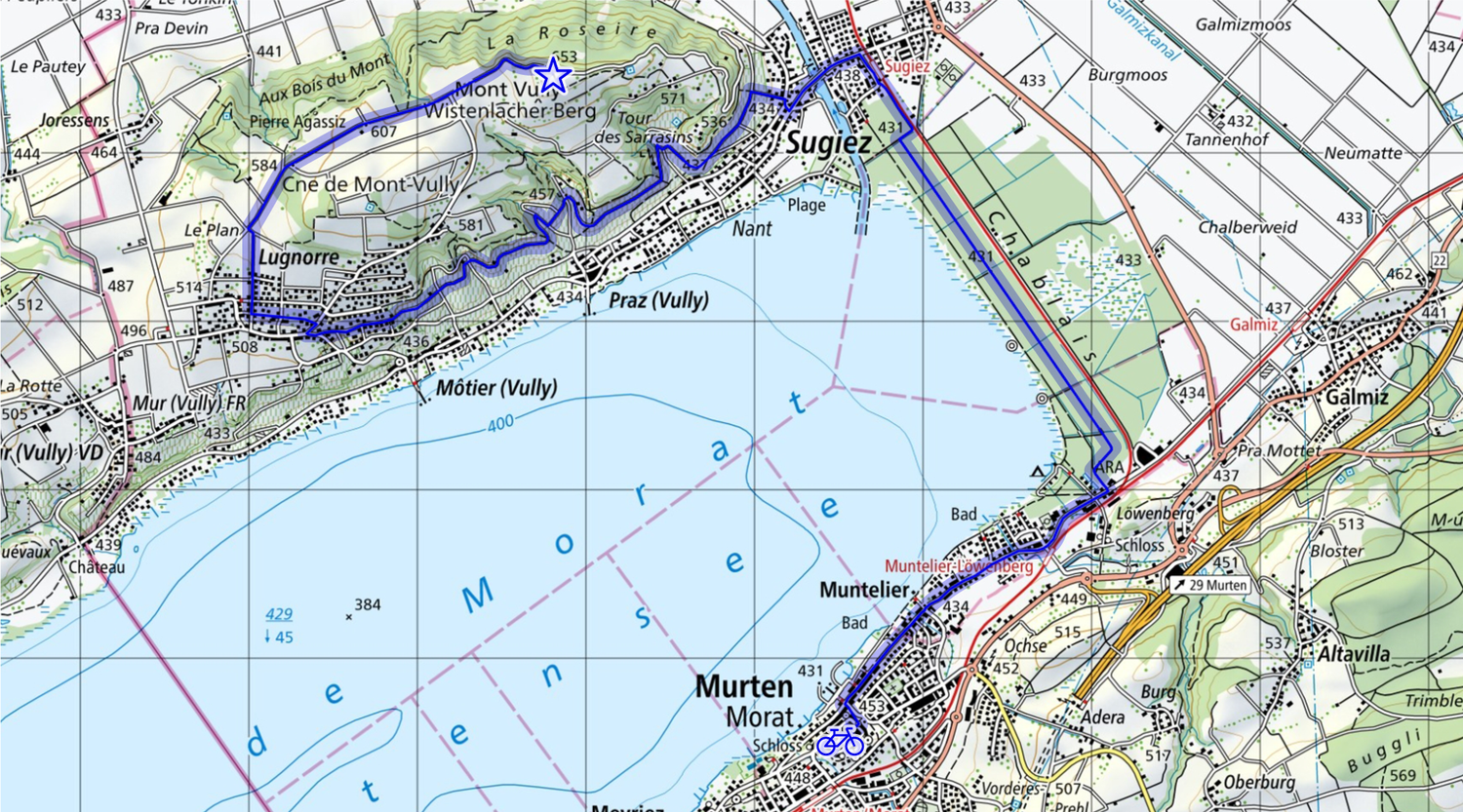
A bike tour combines sport, recreation, and relaxation all in one. Discover how to plan a varied route from Murten up to Mont Vully. The journey takes you along the lake and through the state forest of Chablais, passing vineyards along the way.
Discover how national maps can help keep your bike tour stress-free and free of unwelcome surprises.
Organising a Bike Tour? It's Easy with the National Map
The area around Lake Murten is truly worth exploring and is ideal for a bike tour — for example, starting in Murten and heading towards Mont Vully as your destination.
There are several ways to plan such a bike tour.:
On one hand, you can use a classic printed map. It is reliable, provides a comprehensive overview of roads and landscape, and does not depend on battery life or internet connection.
On the other hand, the online map viewer at map.geo.admin.ch offers a wide selection of maps. It also provides a wealth of additional information, allowing you to measure distances and view elevation profiles.
The swisstopo app for smartphones also offers similar features. Maps and tours are also available offline. During your bike tour, the “companion” feature provides real-time details about the route, elevation changes, and duration.
The most elegant option is the personalised mySwissMap. With this service, you can create a bespoke map perfectly tailored to your route and individual preferences and have it printed.
Tip
If you plan your bike tour with a printed map,
use maps at 1:50,000 or 1:25,000 scale for best detail.
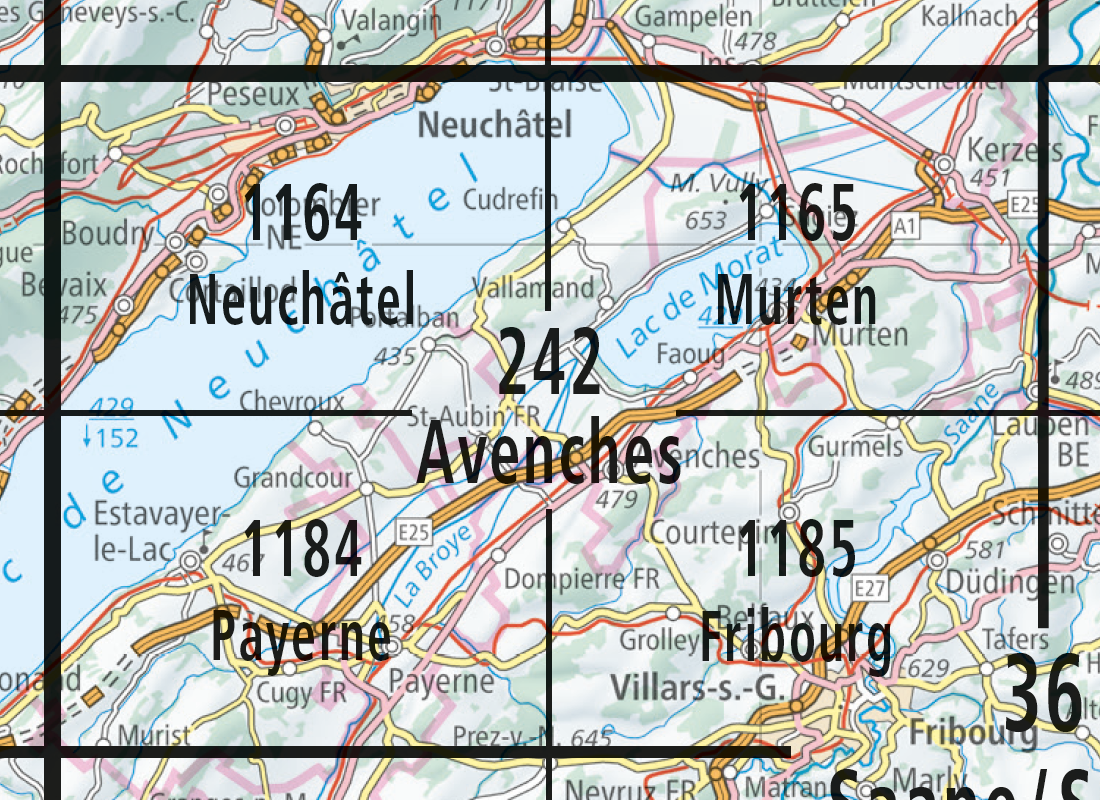
Note that the featured route fits on one 1:25,000 map (1:25,000, 1165 Murten).
If your tour crosses map borders,
choose a 1:50,000 (242 Avenches) map or create a custom mySwissMap.
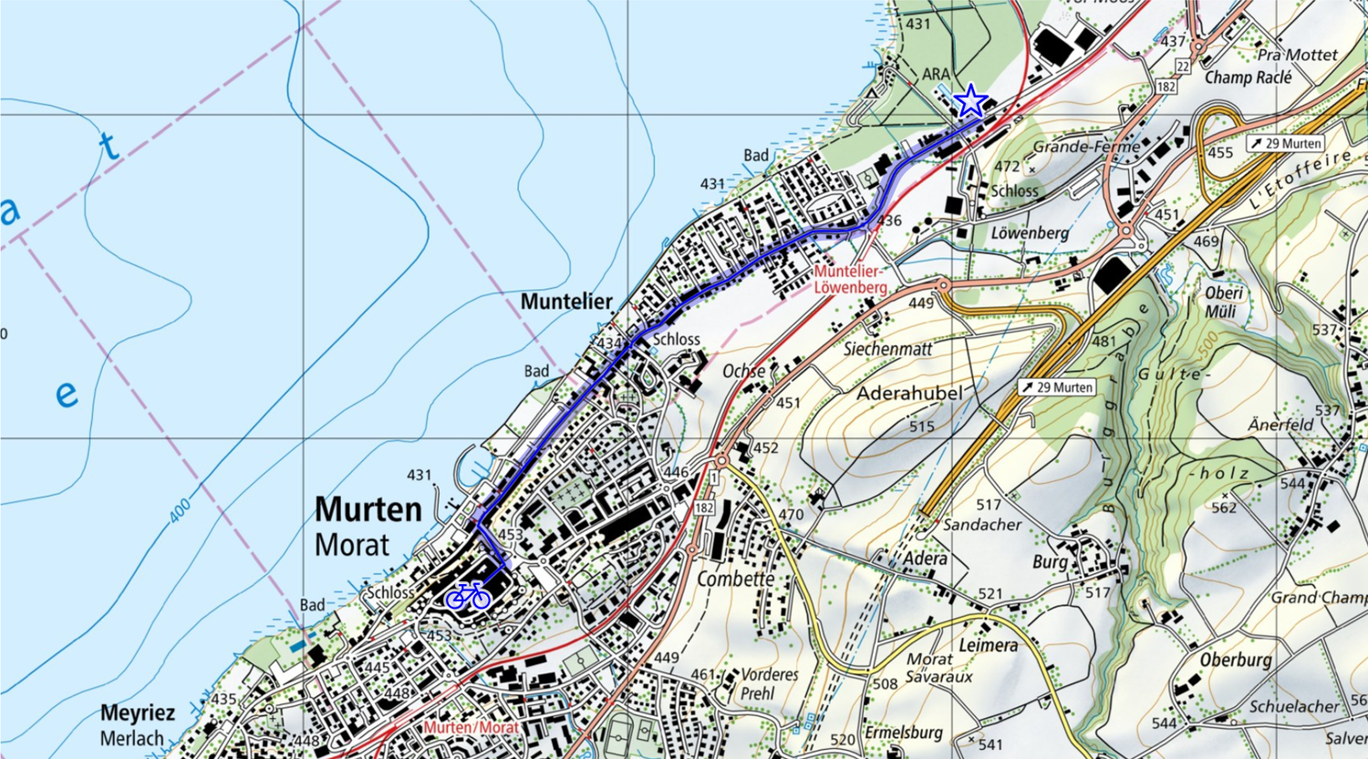
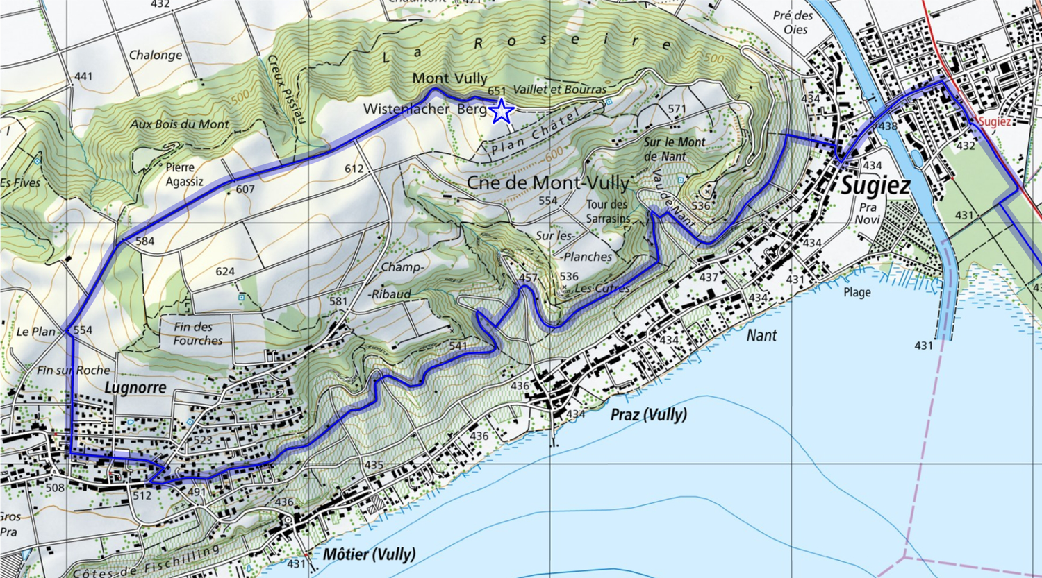
The first stage leads from Murten to the Chablais state forest. There are many ways to reach Mont Vully. To simplify planning, use the road symbols on topographic maps. These are thoroughly explained in our article “Difference between roads and tracks”.
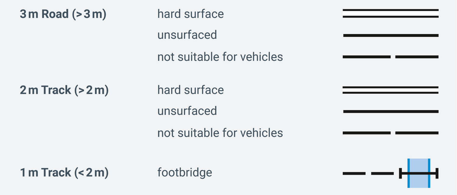
Paths marked as 1 metre wide are often only accessible to pedestrians. The wider the road, the more traffic you can expect. Therefore, it is advisable to choose a route that includes as many 2-metre paths and 3-metre roads as possible.
Using these criteria, you can select the route from Murten to the Chablais forest.
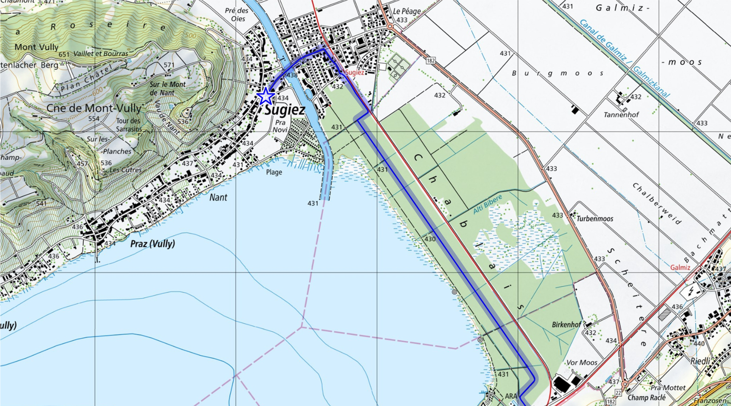
There are three options to cross the forest; choose the best path. If you prefer to keep the water in sight, you might instinctively choose the lakeside route. However, notice the many blue lines on the map.

The legend clarifies that these blue lines represent wetland. Since you neither have a mountain bike nor want to end the day with muddy clothes, you decide against this route.
The path along the railway line is also less ideal, as the tracks block access to the lakeshore from the start to the end of the forest.
Thus, you choose the 2-metre-wide path in the middle, which allows access to the lakeshore thanks to regular cross-connections.
On the last stretch, you can enjoy the vineyards. Naturally, you’ll want to find a path through the wine-growing area.
Do you know how to recognise vineyards on the map?
They are marked with a distinctive symbol on the national map.

From Sugiez to the viewpoint on Mont Vully, you will ascend 219 metres—a sporty challenge that you’ll want to tackle without side stitches.
Index contours and spot heights
Counting contour lines is rather laborious and prone to errors. That is why there are so-called index contours and spot heights. These features make it easier to estimate or calculate differences in elevation, both in lakes and on land. Spot heights mark points of specific elevation, typically hills, mountains, depressions, village squares, road junctions, and similar landmarks.
However, index contours are simply regular contour lines that are drawn slightly thicker every 100 metres.

Find out more about contour lines here: Contour lines: The enigma of terrain profiles
Your bike tour planning is now complete. Of course, closed paths or construction sites may disrupt your plan. But since you have thoroughly studied the route in advance, you will find it easy to identify alternative detours or bypasses.
Map reading is in!
Being able to read maps is not just a useful skill for outdoor enthusiasts, it's helpful when planning a trip, too. With a bit of practice and the right information, you can organise your trips even better and impress your friends with your expertise. What's more, our famed Swiss national maps are among the most detailed and precise in the world. By the way: it does not matter whether you use swisstopo maps on your smartphone or on paper, as the key is always the same.
Want to learn more? You can find more information in the signs and symbols list (also known as a key) for all swisstopo maps: Map reading | swisstopo online shop (admin.ch)
Federal Office of Topography swisstopo
Seftigenstrasse 264
3084 Wabern