
News about geodata
In this section you will find information about updates and news concerning swisstopo's geodata.

Subscribe to Geodata Newsletter
The Geodata Newsletter provides you with regular information on the latest innovations in the world of swisstopo geodata.
New Updates
Overview of the new geodata made available for download in the last 12 months

swissSURFACE3D Raster Update July 2026
The latest data from swissSURFACE3D Raster is now available for the cantons of Fribourg, Geneva, Neuchâtel and Vaud.

New slope class
After discussion with the WSL Institute for Snow and Avalanche Research SLF and the Swiss Alpine Club SAC, swisstopo has introduced a new class for slopes exceeding 50° in the slope classes layer. The aim is to improve readability. The changes are visible immediately in the slope classes layer on map.geo.admin.ch and in the swisstopo app.
swissALTIRegio Update June 2026
The latest edition of swissALTIRegio is now available for download. We have integrated new data for the cantons of Basel-Landschaft, Basel-Stadt, Berne and Solothurn.

swissBUILDINGS3D 3.0 Beta Update June 2026
In swissBUILDINGS3D 3.0 Beta, 3D building models with the federal building identifier (EGID) are now also available for the cantons of Nidwalden, Obwalden and Uri. Furthermore, the cantons of Aargau and Schaffhausen have been updated.
SWISSIMAGE Update May 2026
Update of the SWISSIMAGE product with images of 2025.The latest images of the canton Glarus are now available.
swissSURFACE3D Update April 2026
Thanks to the latest publication from swissSURFACE3D, the latest generation of LiDAR data is now available across the cantons of Vaud and Fribourg.

Swiss Map Web products Update April 2026
The vector tilesets ‘Base’ (ch.swisstopo.base.vt) and ‘Relief’ (ch.swisstopo.relief.vt) have been updated with the latest data.

swissNAMES3D Update April 2026
swisstopo has published the 2026 edition of swissNAMES3D. With over 490000 geo-referenced entries, swissNAMES3D is the most comprehensive collection of Swiss geographic names. As a new feature, the product now includes the names of populated places also as point objects. These center points enable more precise placement of this name category in cartographic products. In addition, swissNAMES3D is now also available as a GeoPackage.
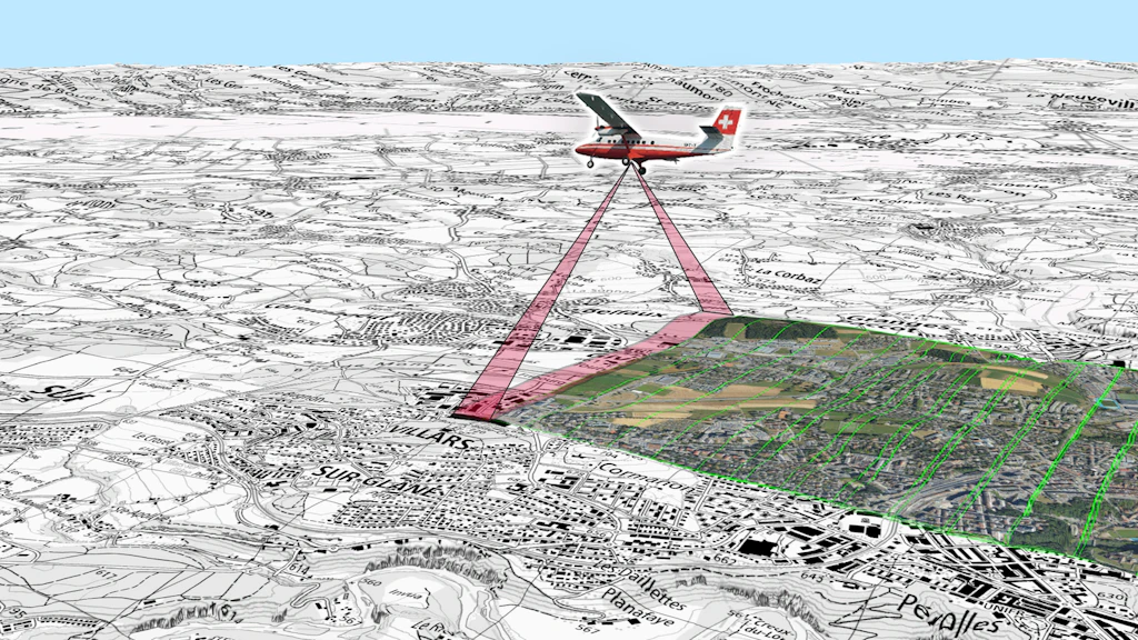
New aerial imaging sensor – evolution and changes in swisstopo products
The acquisition of aerial images constitutes one of the essential foundations for the production of national geodata by the Federal Office of Topography swisstopo. These data are used in particular for updating the topographic landscape model, national maps, as well as for producing the SWISSIMAGE orthophoto mosaic. In order to keep pace with the rapid evolution of aerial imaging technologies and to further improve the quality and efficiency of its surveys, swisstopo is modernising its sensor system and evolving several products in its catalogue.
swissSURFACE3D Raster Update April 2026
The latest data from swissSURFACE3D Raster is now available for the cantons of Appenzell Ausserrhoden, Appenzell Innerrhoden, Glarus, St. Gallen, Schaffhausen, Schwyz, Thurgau, Zug and Zurich, as well as the Principality of Liechtenstein.

swissTLM-Map Update April 2026
swisstopo has updated the map display of swissTLM-Map with the latest data of the topographic landscape model (TLM), as well as the corresponding layers in map.geo.admin.ch.

swissSURFACE3D second Update March 2026
The latest generation of LiDAR data is now available for the areas covered by the 1:25,000 national map sheets numbers 1203, 1204, 1205, 1206, 1223, 1224, 1225, 1226, 1243, 1245, 1246 and 1265.


Federal Office of Topography swisstopo
Seftigenstrasse 264
3084 Wabern